Picture yourself standing at the edge of the Grand Canyon, the Colorado River winding through like a silvery thread stitching together a tapestry of rugged landscapes. The Colorado River map isn’t just a bunch of lines and dots—it’s your roadmap to adventure! Spanning seven states and two countries, this river carves through some of the most jaw-dropping scenery on Earth. Whether you’re a thrill-seeker itching to raft its rapids, a nature lover craving serene hikes, or just curious about its path, understanding the Colorado River map unlocks a world of possibilities. Let’s dive into this guide and trace the river’s epic journey together. Ready to navigate?
Why the Colorado River Map Matters
The Colorado River isn’t just a waterway; it’s a lifeline for the American Southwest. Stretching over 1,450 miles from the Rocky Mountains to the Gulf of California, it feeds cities, farms, and ecosystems. But why should you care about its map? Because it’s your key to unlocking hidden gems, planning epic trips, and understanding the region’s geography. A good map shows you where to raft, hike, or simply soak in the views. It’s like having a treasure map, except instead of gold, you’re chasing sunsets and stories.
A Quick Look at the River’s Path
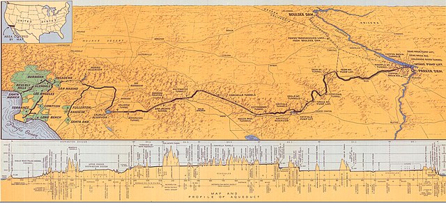
The Colorado River starts high in Colorado’s Rocky Mountains, trickling from La Poudre Pass. From there, it gathers strength, carving through Utah, Arizona, Nevada, and California before crossing into Mexico. Along the way, it sculpts iconic landmarks like the Grand Canyon and powers massive dams like Hoover Dam. A Colorado River map highlights these key points, showing you where the action happens. Think of it as the river’s resume—impressive and full of highlights!
Key Features of a Colorado River Map

Not all maps are created equal. A solid Colorado River map should be detailed, user-friendly, and packed with info. Whether you’re using a paper map, a digital app, or an interactive online tool, here’s what to look for to make your adventure seamless.
Topographic Details
Topographic maps show elevation changes, which is crucial for hikers and rafters. The Colorado River cuts through canyons and plateaus, so knowing the terrain helps you plan. Ever tried hiking a steep canyon without warning? Spoiler: it’s not fun. Look for maps with contour lines to gauge the landscape’s ups and downs.
Major Landmarks and Dams
From Glen Canyon Dam to Lake Mead, the river’s dams are engineering marvels. A good map marks these, along with natural wonders like Horseshoe Bend. These landmarks aren’t just pretty—they’re practical waypoints for navigation. Imagine pulling over at Lake Powell for a spontaneous swim. A map makes that dream a reality.
Access Points and Roads
Want to dip your toes in the river? Maps highlight access points like boat ramps, campgrounds, and trailheads. They also show nearby roads, so you’re not stuck guessing how to reach that perfect spot. It’s like having a local guide whispering, “Turn here!”
Top Destinations Along the Colorado River
The Colorado River map is dotted with must-see spots. Whether you’re chasing adventure or tranquility, these destinations deserve a place on your itinerary. Let’s explore a few that’ll make your heart race or your jaw drop.
Grand Canyon National Park
No Colorado River guide is complete without the Grand Canyon. The river carved this 277-mile-long wonder over millions of years, and rafting through it feels like time travel. Maps of this area show key rapids, campsites, and viewpoints like Desert View. Pro tip: South Rim is busier, but North Rim offers quieter trails.
Rafting the Grand Canyon
Rafting trips range from one-day jaunts to multi-week epics. A detailed map shows rapids like Lava Falls, rated a heart-pounding 10. Not a rafter? Hike down Bright Angel Trail for river views. Either way, a map keeps you oriented in this vast wilderness.
Lake Powell and Glen Canyon
Lake Powell, formed by Glen Canyon Dam, is a boater’s paradise. Its turquoise waters contrast with red rock cliffs, creating postcard-worthy scenes. Maps here highlight marinas, slot canyons, and spots for houseboating. Ever slept under the stars on a lake? It’s magical.
Horseshoe Bend
Just downstream from Lake Powell, the river loops into the iconic Horseshoe Bend. A short hike leads to a cliff overlooking this U-shaped marvel. Maps show parking and trails, making it easy to snap that Insta-worthy shot. Sunrise visits beat the crowds!
Planning Your Colorado River Adventure

Ready to hit the river? Planning is key, and a Colorado River map is your best friend. Here’s how to turn your dream trip into reality without breaking a sweat.
Choosing the Right Map
Digital maps like Google Maps are great for road trips, but for backcountry adventures, grab a topographic map from the USGS or National Geographic. Apps like Gaia GPS offer offline access, perfect for remote areas. Test your map before you go—nothing’s worse than a dead battery in the wild.
Paper vs. Digital Maps
Paper maps don’t rely on signal or battery, making them reliable for remote stretches. Digital maps, though, let you zoom in and track your location in real-time. Why not use both? It’s like having a backup plan for your backup plan.
Permits and Regulations
Many areas, like Grand Canyon National Park, require permits for rafting or camping. Check regulations on your map’s key or companion guide. Ignoring rules can lead to fines or, worse, missing out on epic spots. Stay legal, stay happy!
Activities to Enjoy Along the Colorado River
The Colorado River isn’t just for looking at—it’s for living! From adrenaline-pumping rapids to chill fishing spots, there’s something for everyone. Let’s break down the top activities to add to your map-based adventure.
Whitewater Rafting
The Colorado’s rapids range from beginner-friendly to expert-only. Popular stretches include Cataract Canyon and Westwater Canyon. Maps mark put-in and take-out points, plus rapid ratings. Feeling brave? Tackle a Class V rapid and tell the tale!
Hiking and Camping
Trails like Havasu Falls lead to turquoise pools, while riverside campgrounds offer starry nights. Maps show trailheads, water sources, and campsites. Pack light, but don’t skimp on water—this desert doesn’t mess around.
Fishing and Wildlife Watching
The river teems with trout, bass, and catfish. Maps point to prime fishing holes, often near dams. Wildlife lovers can spot bighorn sheep or bald eagles. Bring binoculars and a map to track those elusive critters.
Environmental Importance of the Colorado River
Beyond adventure, the Colorado River is an ecological powerhouse. It supports 40 million people and vast ecosystems, but it’s under strain. Understanding its role adds depth to your map-guided journey.
Water Supply and Agriculture
The river irrigates 5.5 million acres of farmland, feeding the U.S. and beyond. Cities like Los Angeles and Phoenix depend on it. Maps often show reservoirs like Lake Mead, critical for water storage. Ever wonder where your salad comes from? Thank the Colorado.
Challenges and Conservation
Overuse and climate change threaten the river’s flow. Some maps highlight conservation areas or low-water zones. Support local efforts by sticking to designated trails and campsites. Small actions, big impact!
Tips for Using a Colorado River Map

A map’s only as good as your ability to read it. Here are pro tips to navigate like a seasoned explorer, whether you’re on the river or dreaming from your couch.
Learn Map Symbols
Maps use symbols for trails, rapids, and more. Study the legend before you go. Mistaking a cliff for a trail isn’t the adventure you want. Practice makes perfect!
Combine with Other Tools
Pair your map with a compass, GPS, or guidebook. Apps like AllTrails complement maps for real-time updates. It’s like assembling your own adventure toolkit.
Conclusion
The Colorado River map is more than a tool—it’s your ticket to unforgettable adventures. From the Grand Canyon’s depths to Lake Powell’s shimmering shores, this river offers endless ways to explore, connect, and marvel. Whether you’re rafting rapids, hiking trails, or simply tracing its path on paper, the Colorado’s story invites you to be part of it. So grab a map, pack your sense of wonder, and hit the river. Where will it take you next?
Frequently Asked Questions
1. What’s the best map for rafting the Colorado River?
Look for topographic maps from National Geographic or USGS, with detailed rapids and access points. Apps like Gaia GPS are great for digital navigation.
2. Can I visit the Colorado River without a permit?
Some areas, like Horseshoe Bend, don’t require permits, but rafting or camping in places like Grand Canyon National Park often does. Check regulations first.
3. Where does the Colorado River start and end?
It begins at La Poudre Pass in Colorado’s Rockies and ends in the Gulf of California, Mexico, though it often dries up before reaching the sea.
4. Are there beginner-friendly activities along the Colorado River?
Absolutely! Try flatwater kayaking on Lake Powell or short hikes like the one to Horseshoe Bend. Maps highlight easy-access spots.
5. How can I help conserve the Colorado River?
Stick to designated trails, reduce water waste, and support local conservation groups. Every little bit helps keep the river flowing!

