
Have you ever wondered what it feels like to drive through a postcard? Welcome to the Apache Trail, Arizona’s legendary Highway 88 that winds through some of the most breathtaking desert landscape in the American Southwest. This isn’t just another scenic drive – it’s a journey through time, terrain, and tales that’ll leave you speechless.
Picture this: you’re cruising along a narrow, winding road carved into ancient mountainsides, with crystal-clear desert lakes reflecting towering saguaro cacti and rugged peaks. One moment you’re navigating hairpin turns above dramatic canyons, the next you’re rolling into a ghost town where the Wild West still lives and breathes. That’s the magic of the Apache Trail, and trust me, it’s unlike anything you’ve ever experienced.
But here’s the thing – the Apache Trail isn’t for everyone. This 40-mile stretch of partially paved, partially dirt road demands respect, preparation, and a sense of adventure. Are you ready to discover why this route has been captivating travelers for over a century? Let’s dive into everything you need to know about conquering Arizona’s most famous scenic highway.
What is the Apache Trail?
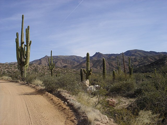
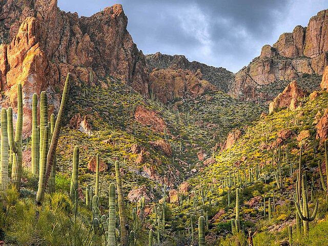
The Apache Trail is Arizona’s Historic Route 88, a winding 40-mile road that connects Apache Junction to Globe, Arizona. But calling it just a road would be like calling the Grand Canyon just a big hole – it’s so much more than that. This legendary route weaves through the Superstition Mountains and Tonto National Forest, passing four pristine desert lakes, ancient Native American ruins, ghost towns, and some of the most dramatic desert scenery you’ll find anywhere in the world.
What makes the Apache Trail truly special isn’t just its stunning beauty – it’s the combination of history, adventure, and raw desert wilderness that creates an experience you simply can’t get anywhere else. This isn’t a highway you’ll cruise down at 70 mph while checking your phone. The Apache Trail demands your full attention and rewards it with memories that’ll last a lifetime.
History of Arizona’s Historic Route 88
The story of the Apache Trail begins long before any European ever set foot in Arizona. For centuries, Apache tribes used these mountain paths to navigate through the harsh Sonoran Desert. These weren’t casual hiking trails – they were lifelines that connected water sources and provided strategic advantages in the unforgiving desert landscape.
The modern Apache Trail was born out of necessity in the early 1900s during the construction of Roosevelt Dam. Engineers needed a way to transport massive amounts of equipment and supplies into the remote Salt River valley. The route they carved through the mountains followed many of the same paths the Apache had used for generations, hence the name “Apache Trail.”
Construction of this supply road was no joke. Workers faced extreme heat, dangerous terrain, and the constant threat of flash floods. Many sections had to be blasted directly into solid rock faces, creating the narrow, winding route we know today. When President Theodore Roosevelt dedicated the completed dam in 1911, he declared the Apache Trail drive to be one of the most spectacular scenic routes in America – and that reputation has only grown stronger over the past century.
Why It’s Called America’s Most Dangerous Highway
Before you start panicking, let’s put this in perspective. The Apache Trail earned its “dangerous” reputation not because it’s a death trap, but because it’s a serious mountain road that doesn’t forgive careless drivers. We’re talking about narrow lanes carved into cliffsides, blind curves that could hide oncoming traffic, and sections where the pavement gives way to well-maintained dirt road.
The “danger” comes from the fact that this isn’t your typical highway experience. There are sections where the road is barely wide enough for two vehicles to pass, especially when you encounter RVs or large trucks. The elevation changes are dramatic, the curves are sharp, and if you’re not paying attention, you could find yourself in serious trouble.
But here’s the reality: thousands of people drive the Apache Trail safely every year. The key is approaching it with the right mindset, proper vehicle preparation, and healthy respect for the terrain. Think of it less like a dangerous highway and more like an advanced scenic driving experience that requires your full attention and preparation.
Apache Trail Route and Stops
The beauty of the Apache Trail lies not just in the drive itself, but in the incredible destinations you’ll discover along the way. Each stop offers something unique, from ghost towns frozen in time to pristine desert lakes that seem impossible in this arid landscape.
Starting Point: Apache Junction
Most Apache Trail adventures begin in Apache Junction, a desert town that sits at the base of the legendary Superstition Mountains. This isn’t just a convenient starting point – Apache Junction is steeped in Wild West lore and serves as your gateway to one of Arizona’s most famous treasure hunting legends.
Apache Junction is where you’ll want to fuel up, grab supplies, and make sure your vehicle is ready for the journey ahead. The town offers plenty of restaurants, gas stations, and shops where you can stock up on water, snacks, and emergency supplies. Don’t skip this preparation step – once you leave Apache Junction, services become scarce until you reach the other end of the trail.
The Superstition Mountains that loom over Apache Junction are home to the legendary Lost Dutchman’s Gold Mine, one of America’s most famous treasure hunting stories. While you’re preparing for your Apache Trail adventure, take a moment to soak in these mysterious peaks that have inspired countless treasure hunters, hikers, and dreamers over the past century.
Goldfield Ghost Town
Just a few miles up the Apache Trail from Apache Junction, you’ll encounter your first major stop: Goldfield Ghost Town. This isn’t some cheesy tourist trap trying to recreate the Old West – Goldfield is a genuine 1890s gold mining town that’s been carefully preserved and restored to give you an authentic taste of Arizona’s mining heritage.
Walking through Goldfield feels like stepping onto a movie set, except everything you’re seeing is real. The original buildings house period-appropriate shops, a saloon that still serves drinks, and museums filled with artifacts from the town’s gold mining heyday. You can even take a ride on a narrow-gauge railroad that winds through the desert, offering spectacular views of the Superstition Mountains.
The best part about Goldfield? It’s not just about looking at history – you can participate in it. Try your hand at gold panning, explore a real mine shaft, or catch one of the regular gunfight reenactments that bring the Wild West to life. It’s touristy, sure, but in the best possible way that honors the area’s authentic history.
Canyon Lake: First Desert Oasis
After leaving Goldfield, the Apache Trail begins to climb into the Superstition Mountains, and that’s when the real scenic drama begins. The road starts winding more dramatically, the views become more spectacular, and suddenly you’ll round a curve to see something that seems impossible in this desert landscape: Canyon Lake, a pristine blue jewel nestled between towering canyon walls.
Canyon Lake is the first of four lakes you’ll encounter on the Apache Trail, and it never fails to amaze first-time visitors. This isn’t a natural lake – it’s created by Mormon Flat Dam – but it looks so perfectly placed in this dramatic canyon setting that you’d swear Mother Nature designed it herself.
The contrast is stunning: brilliant blue water surrounded by red rock canyon walls, towering saguaro cacti, and desert vegetation that somehow thrives in this harsh environment. It’s like someone dropped a piece of Lake Powell into the middle of the Sonoran Desert, and the result is absolutely breathtaking.
Canyon Lake Marina and Activities
Canyon Lake isn’t just a pretty view – it’s a full-service recreation destination that offers everything from boat rentals to guided tours. The Canyon Lake Marina provides boat rentals, fishing supplies, and even pontoon boat tours that take you deep into the narrow canyon arms where the scenery becomes even more dramatic.
Fishing at Canyon Lake is legendary among Arizona anglers. The lake is regularly stocked with rainbow trout, and it also holds populations of bass, catfish, and yellow bass. The combination of clear, deep water and dramatic scenery makes fishing here an experience that goes far beyond just catching fish.
If you’re not into boating or fishing, don’t worry – Canyon Lake offers plenty for land-based visitors too. The day-use area includes picnic tables, restrooms, and a beach area where you can wade in the surprisingly refreshing water. There are also several hiking trails that offer different perspectives on the lake and surrounding canyon country.
Tortilla Flat: Population 6
Continuing up the Apache Trail, you’ll encounter one of Arizona’s most famous tiny towns: Tortilla Flat, with a official population of 6 people. This isn’t a ghost town – it’s a living, breathing community that happens to be really, really small. And despite its tiny size, Tortilla Flat has become one of the most photographed stops along the entire Apache Trail.
What makes Tortilla Flat so special? It’s the perfect combination of authentic Western character and quirky charm. The town consists of essentially one main building that houses a restaurant, saloon, general store, and post office. The walls are covered with dollar bills left by visitors from around the world, creating a unique form of international graffiti that’s been building up for decades.
The atmosphere in Tortilla Flat is unlike anywhere else you’ll visit. It’s simultaneously touristy and authentic, commercialized yet genuine. The locals who run the place are characters straight out of a Western novel, and they’ll gladly share stories about life in one of America’s smallest towns.
The Famous Tortilla Flat Saloon
The saloon at Tortilla Flat isn’t just a bar – it’s a Western institution. Step inside and you’ll find yourself surrounded by thousands of dollar bills pinned to the walls and ceiling, each one signed by visitors from around the world. It’s like a papery timeline of everyone who’s made the Apache Trail journey before you.
The food at Tortilla Flat is hearty Western fare that hits the spot after hours of mountain driving. Their famous prickly pear cactus ice cream is a must-try – it sounds weird, but it’s surprisingly delicious and perfectly captures the unique character of this desert outpost.
But the real attraction isn’t the food or even the dollar-covered walls – it’s the atmosphere. Tortilla Flat feels like a place where time moves differently, where the pace of modern life slows down to match the rhythm of the desert. It’s a place where strangers become friends over shared stories of their Apache Trail adventures.
Apache Lake: Hidden Gem
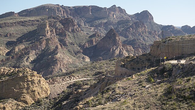
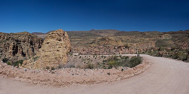
Beyond Tortilla Flat, the Apache Trail becomes more challenging and more rewarding. The pavement ends and gives way to well-maintained dirt road, and the scenery becomes even more dramatic. This is where you’ll discover Apache Lake, arguably the most beautiful and certainly the most secluded of the four Salt River lakes.
Apache Lake feels like a secret that only serious adventurers get to discover. The lake is longer and narrower than Canyon Lake, snaking deep into side canyons that create intimate coves and hidden beaches. The water is typically the clearest and bluest of all the Salt River lakes, and because it requires more effort to reach, it’s usually less crowded than the more accessible lakes.
The drive to Apache Lake is where the Apache Trail really lives up to its reputation. The dirt road section isn’t difficult if you’re prepared, but it does require attention and respect. You’ll navigate switchbacks that offer incredible views, cross washes that could be dangerous during flash flood season, and climb through terrain that truly feels remote and wild.
Fishing and Boating Paradise
Apache Lake is a paradise for serious anglers and boaters who don’t mind working a little harder to find their perfect spot. The lake holds excellent populations of bass, catfish, and other warm-water species, and because it gets less fishing pressure than the more accessible lakes, the fishing can be outstanding.
The remote location and dramatic scenery make Apache Lake perfect for multi-day camping and boating trips. There are numerous secluded coves where you can anchor your boat and feel like you’ve discovered your own private desert oasis. The silence out here is profound – no city noise, no highway traffic, just the gentle lapping of water against red rock shores.
For those without boats, Apache Lake still offers excellent shore fishing opportunities and hiking trails that provide access to hidden viewpoints and swimming spots. The lake’s remote location means you’ll often have these spots entirely to yourself, creating an experience that feels more like wilderness exploration than typical lake recreation.
Roosevelt Lake and Dam
The Apache Trail’s grand finale is Roosevelt Lake, Arizona’s largest lake and the site of one of the most important engineering achievements in the American West. Roosevelt Dam, completed in 1911, was the world’s highest masonry dam at the time of its construction and remains one of the most impressive examples of early 20th-century engineering.
Engineering Marvel in the Desert
Roosevelt Dam isn’t just impressive for its size – it’s remarkable for where it was built and how it was constructed. Remember, this massive structure was built in the early 1900s in one of the most remote locations in Arizona. Every piece of equipment, every bag of cement, every steel beam had to be transported over the Apache Trail when it was nothing more than a rough mountain track.
The dam’s construction required innovative solutions to seemingly impossible problems. Workers had to quarry stone from nearby mountains, mix concrete in the desert heat, and build massive structures in a location that was days away from the nearest railroad. The Apache Trail itself was built primarily to support this construction project, which gives you some idea of the scale and importance of Roosevelt Dam.
Today, Roosevelt Dam continues to serve its original purposes: flood control, water storage, and hydroelectric power generation. But it’s also become a destination in its own right, offering visitors a chance to see one of the engineering marvels that helped make modern Arizona possible.
Roosevelt Lake State Park
Roosevelt Lake State Park encompasses the entire shoreline of Arizona’s largest lake, offering everything from developed campgrounds to remote wilderness camping. The park’s diverse recreational opportunities make it a perfect ending point for your Apache Trail adventure, whether you want to relax after the challenging drive or continue your outdoor adventures on the water.
The lake itself is massive – when full, it covers over 21,000 acres and offers more than 100 miles of shoreline to explore. This size means Roosevelt Lake can accommodate every type of water recreation, from quiet fishing in secluded coves to high-speed water skiing on the main lake body.
What makes Roosevelt Lake State Park special is its diversity. You can find developed campgrounds with full amenities, primitive camping spots where you’ll have the desert to yourself, hiking trails that range from easy walks to challenging backcountry routes, and water access points that cater to everything from small fishing boats to large houseboats.
Tonto National Monument
While not technically on the Apache Trail itself, Tonto National Monument is close enough to warrant a detour and offers a fascinating glimpse into the area’s ancient history. This small but significant monument preserves some of the best-preserved cliff dwellings in the Southwest, built by the Salado people over 700 years ago.
Ancient Cliff Dwellings
The cliff dwellings at Tonto National Monument tell a story that predates the Apache Trail by centuries. The Salado people chose this location for the same reasons modern visitors find it appealing: water, protection, and stunning views of the surrounding landscape. These aren’t massive ruins like you’ll find at Mesa Verde, but they’re remarkably well-preserved and offer intimate insights into how people lived in this challenging environment.
The monument’s visitor center provides excellent context for understanding Salado culture and the challenges of desert living. Rangers lead guided tours to the upper ruins that aren’t accessible on your own, and these tours provide incredible insights into ancient desert survival techniques, architectural innovations, and the complex trade networks that connected these remote communities to distant civilizations.
The views from the cliff dwellings are spectacular, offering perspectives on Roosevelt Lake and the surrounding mountains that help you understand why the Salado people chose this location. It’s also a great place to reflect on the continuity of human habitation in this area – from ancient cliff dwellers to Apache travelers to modern adventurers following the same basic routes through this challenging but beautiful landscape.
Best Time to Drive the Apache Trail
Timing your Apache Trail adventure correctly can make the difference between a good trip and an unforgettable one. Arizona’s desert climate creates dramatically different experiences depending on when you visit, and understanding these seasonal variations will help you plan the perfect journey.
Seasonal Considerations
Fall through early spring (October through April) offers the most comfortable weather for Apache Trail adventures. Daytime temperatures typically range from the 60s to 80s, making it perfect for both driving and outdoor activities. This is peak season for desert recreation, which means more crowds but also better road maintenance and more services available at stops along the way.
Winter can be surprisingly pleasant on the Apache Trail, with daytime temperatures often reaching into the 70s. However, elevation changes along the route mean you might encounter occasional snow or ice at higher elevations, particularly early in the morning. Winter also brings the possibility of winter storms that can make the dirt sections more challenging.
Spring is arguably the best time to experience the Apache Trail. March through May offers perfect weather, and if winter rains have been adequate, you’ll be rewarded with spectacular wildflower displays throughout the desert. The cacti blooming season typically peaks in April and May, adding brilliant colors to the already stunning landscape.
Weather and Road Conditions
Summer presents significant challenges for Apache Trail travelers. Temperatures routinely exceed 100°F, making vehicle breakdowns potentially dangerous and outdoor activities uncomfortable or even hazardous. If you must travel the Apache Trail during summer, start very early in the morning, carry extra water, and avoid the hottest part of the day.
The monsoon season (July through September) creates additional complications. While the dramatic thunderstorms can create spectacular scenery and photography opportunities, they also bring the risk of flash floods that can make the dirt sections of the Apache Trail impassable. Always check current weather conditions and flash flood warnings before attempting the trail during monsoon season.
Road conditions can vary significantly depending on recent weather and maintenance schedules. The paved sections are generally well-maintained year-round, but the dirt sections between Tortilla Flat and Roosevelt Lake can become challenging after heavy rains or during periods of deferred maintenance. Check with local authorities or recent traveler reports before making the journey.
Apache Trail Safety Tips
The Apache Trail’s reputation as a challenging drive isn’t just marketing hype – it’s a serious mountain road that requires preparation, respect, and common sense. But don’t let that scare you away. With proper planning and precautions, the Apache Trail is absolutely safe for any competent driver with a suitable vehicle.
Vehicle Requirements
You don’t need a massive 4×4 truck to drive the Apache Trail, but you do need a vehicle that’s appropriate for mountain driving and dirt roads. Any car with decent ground clearance, good tires, and reliable brakes can handle the trail. However, low-slung sports cars, heavily loaded vehicles, or cars with mechanical problems should probably skip this adventure.
The most important vehicle consideration is tire condition. The combination of sharp rocks, extreme temperatures, and remote locations makes tire failure particularly problematic on the Apache Trail. Make sure your tires have good tread, proper inflation, and no obvious signs of wear or damage. Carrying a full-size spare tire is essential – those temporary “donut” spares aren’t adequate for getting you out of the backcountry.
Your cooling system needs to be in top condition for Apache Trail driving. The combination of steep grades, hot weather, and slow speeds can stress any cooling system. Make sure your coolant levels are proper, your radiator is clean, and your cooling system has been recently serviced. Overheating in the middle of the Apache Trail is not just inconvenient – it can be dangerous.
Essential Supplies and Precautions
Water is your most important supply on the Apache Trail. Even if you’re just making a day trip, carry at least one gallon of water per person. The desert environment can dehydrate you quickly, and if you experience vehicle problems or have to walk for help, adequate water could literally save your life.
Emergency supplies should include basic tools, jumper cables, emergency food, first aid supplies, and a reliable communication device. Cell phone coverage is spotty at best along much of the Apache Trail, so consider carrying a satellite communicator if you’re traveling alone or in a single vehicle.
Tell someone your travel plans before departing, including your intended route, stops, and expected return time. The Apache Trail isn’t a place where you want to rely on chance encounters if you need help. Having someone who knows where you are and when to expect you back provides an important safety net.
Photography and Scenic Viewpoints
The Apache Trail offers some of the most spectacular desert photography opportunities in Arizona, with dramatic landscapes that change constantly as you wind through different elevations and terrain types. Whether you’re a serious photographer or just want to capture memories of your adventure, knowing the best viewpoints and timing can make all the difference.
Best Photo Spots Along the Trail
The overlook just past Canyon Lake offers one of the most iconic Apache Trail views, with the deep blue lake contrasting dramatically against red rock canyon walls and desert vegetation. Early morning or late afternoon light creates the most dramatic contrasts and brings out the rich colors in the rock formations.
The switchbacks above Apache Lake provide multiple opportunities for spectacular photographs that capture the trail’s challenging terrain and remote beauty. These elevated viewpoints show the narrow, winding road carved into cliffsides, with the lake far below and desert mountains stretching to the horizon.
Tortilla Flat itself is endlessly photogenic, from the quirky buildings covered in dollar bills to the characters who call this tiny town home. The combination of authentic Western atmosphere and stunning natural surroundings creates photography opportunities that capture both the human and natural history of the Apache Trail.
Roosevelt Dam offers impressive architectural photography opportunities, especially when contrasted against the natural desert landscape. The massive masonry structure demonstrates human engineering achievement in a wilderness setting, creating dramatic compositions that tell the story of how this remote area was developed.
Where to Stay Near Apache Trail
While the Apache Trail can be conquered in a long day trip, staying overnight near the route allows you to explore more thoroughly and avoid the stress of rushed mountain driving. Several accommodation options cater to different preferences and budgets.
Accommodation Options
Apache Junction offers the most accommodation choices, from budget motels to upscale resorts that cater to snowbirds and desert enthusiasts. Many visitors prefer to base themselves here, making day trips into the Apache Trail and returning to comfortable amenities each evening.
For those seeking a more immersive experience, camping options exist at several points along the Apache Trail. Canyon Lake offers developed campgrounds with amenities, while Roosevelt Lake State Park provides both developed and primitive camping options. These locations put you right in the heart of the desert landscape and allow you to experience the profound silence and star-filled skies that make the desert so magical.
Several guest ranches and resorts in the greater Superstition Mountains area offer upscale accommodations with easy Apache Trail access. These properties combine luxury amenities with authentic desert experiences, perfect for travelers who want to explore the trail without sacrificing comfort.
Apache Trail Day Trip vs Multi-Day Adventure
Deciding whether to tackle the Apache Trail as a day trip or extend it into a multi-day adventure depends on your interests, schedule, and how deeply you want to explore this remarkable area.
A day trip allows you to experience the essential Apache Trail highlights: the scenic drive, major stops like Tortilla Flat and Canyon Lake, and the satisfaction of completing one of Arizona’s most famous scenic routes. This option works well for travelers with limited time or those who prefer to return to comfortable accommodations each evening.
Multi-day adventures allow you to truly immerse yourself in the desert experience. You can camp beside pristine lakes, explore hiking trails that most day-trippers never see, try your luck at fishing or boating, and experience the profound peace that comes with spending nights in this remote landscape. You’ll also have more flexibility to adjust your schedule based on weather, road conditions, or simply the desire to spend more time at a particularly beautiful location.
The multi-day approach also allows you to explore beyond the main Apache Trail route. You can visit Tonto National Monument, explore side roads and hiking trails, or continue on to Globe and the fascinating mining history of that area. This approach transforms the Apache Trail from a scenic drive into a comprehensive desert adventure.
Conclusion
The Apache Trail isn’t just a scenic drive – it’s a journey through some of the most spectacular and historically significant landscape in the American Southwest. From the moment you leave Apache Junction and climb into the Superstition Mountains until you reach Roosevelt Lake’s engineering marvel, every mile offers new discoveries and unforgettable experiences.
This legendary route combines natural beauty, Wild West history, outdoor adventure, and engineering achievement in ways that few destinations can match. Whether you’re drawn by the challenge of navigating a genuine mountain road, the appeal of pristine desert lakes, the charm of authentic Western towns, or simply the desire to experience one of Arizona’s most famous scenic routes, the Apache Trail delivers experiences that go far beyond typical sightseeing.
Yes, the Apache Trail requires preparation, respect, and a sense of adventure. But for those willing to meet its challenges, it offers rewards that last a lifetime. In a world where genuine wilderness experiences are becoming increasingly rare, the Apache Trail remains a place where you can still experience the raw beauty and authentic character that made the American West legendary.
Pack your water, check your tires, fuel up your sense of adventure, and prepare for a journey that will remind you why some roads are worth traveling slowly. The Apache Trail is waiting, and trust me, it’s everything the legends promise and more.
Frequently Asked Questions
1. How long does it take to drive the complete Apache Trail?
The complete Apache Trail from Apache Junction to Roosevelt Lake takes 4-6 hours of driving time, depending on road conditions and how often you stop. However, most visitors spend 8-12 hours total to allow time for sightseeing, photography, and stops at attractions like Tortilla Flat and Canyon Lake. Plan for a full day to properly experience everything the trail offers.
2. Do I need a 4-wheel drive vehicle to drive the Apache Trail?
No, a 4-wheel drive vehicle is not required for the Apache Trail. Any vehicle with adequate ground clearance, good tires, and reliable brakes can complete the route. However, the dirt section between Tortilla Flat and Roosevelt Lake does require careful driving and attention to road conditions. Low-clearance sports cars or heavily loaded vehicles should avoid this route.
3. Is the Apache Trail open year-round?
Yes, the Apache Trail is generally open year-round, but conditions can vary significantly by season. Summer heat can make the drive uncomfortable and potentially dangerous if you experience vehicle problems. Winter occasionally brings snow to higher elevations. Monsoon season (July-September) can create flash flood conditions that temporarily close sections of the trail. Always check current conditions before traveling.
4. What should I bring for an Apache Trail day trip?
Essential supplies include plenty of water (at least 1 gallon per person), snacks, emergency supplies, first aid kit, tools, spare tire, and sun protection. Don’t forget your camera – the scenery is incredible! Cell phone coverage is limited, so inform someone of your travel plans. Bring cash for stops in Tortilla Flat, as credit card acceptance may be limited.
5. Can RVs and large trucks drive the Apache Trail?
Large RVs and trucks can drive parts of the Apache Trail but should avoid the dirt section between Tortilla Flat and Roosevelt Lake. This section has narrow passages, tight curves, and limited room for large vehicles to pass each other. Most RVs can comfortably reach Canyon Lake and Tortilla Flat, but should return via the same route rather than attempting the complete loop to Roosevelt Lake.