
Imagine a green ribbon of mountains stretching along the western coast of India, teeming with wildlife, rich in history, and vital to the climate. That’s the Western Ghats for you—a natural wonder that’s as fascinating on a map as it is in real life. Let’s explore what makes this range so unique and why its map holds so many secrets.
Geographical Overview

States Covered
The Western Ghats span six Indian states: Gujarat, Maharashtra, Goa, Karnataka, Kerala, and Tamil Nadu. Each state adds its own flair to the range, from lush forests to stunning hill stations.
Length and Location
Stretching over 1,600 kilometers, the Western Ghats start near the border of Gujarat and Maharashtra and extend all the way down to Kerala and Tamil Nadu. This mountain range runs parallel to the Arabian Sea, forming a natural barrier that affects regional weather patterns.
Significance of the Western Ghats
Ecological Importance
Ever heard of a biodiversity hotspot? The Western Ghats is one of just 36 in the world. It’s home to over 7,400 species of plants and animals, many of which are found nowhere else on the planet.
UNESCO World Heritage Status
In 2012, UNESCO declared the Western Ghats a World Heritage Site, acknowledging its unique ecosystems, rare species, and cultural richness. A map of this region isn’t just a guide—it’s a gateway to understanding global ecological treasure.
Western Ghats Map: A Visual Guide

Key Landmarks Highlighted
When you glance at a Western Ghats map, you’ll notice famous peaks like Anamudi in Kerala, the tallest in the range. Then there are places like the Nilgiri Hills and Agasthyamala, each with its own identity and history.
National Parks and Wildlife Sanctuaries
The map lights up with green dots representing protected areas—Silent Valley National Park, Periyar Wildlife Sanctuary, Kudremukh National Park, and more. These sanctuaries protect endangered species and pristine habitats.
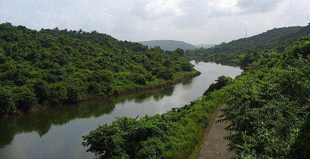
Rivers Originating from the Ghats
The Western Ghats are often called the “Water Tower of South India.” Rivers like the Godavari, Krishna, and Kaveri all originate here. Follow their trails on a map, and you’ll understand their importance to millions.
Biodiversity in the Western Ghats
Flora
Think of an endless green blanket—rainforests, montane forests, and grasslands. The region is home to more than 4,000 species of flowering plants.
Fauna
From tigers to tree frogs, the Ghats are buzzing with life.
Endemic Species
More than 300 species of animals and over 1,500 plant species are endemic, meaning they are found only here. That includes the Malabar civet and the Lion-tailed macaque.
Threatened Species
Unfortunately, many of these unique creatures are endangered. Habitat loss and poaching have put species like the Nilgiri Tahr and the Great Indian Hornbill at risk.
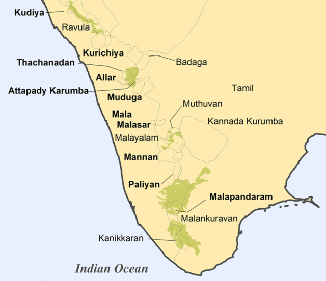
Cultural and Historical Importance

Sacred Groves and Temples
Many communities consider parts of the Western Ghats sacred. You’ll find ancient temples tucked deep within forests and sacred groves maintained for centuries.
Ancient Trade Routes
Historically, the Ghats served as vital trade links between coastal ports and inland kingdoms. Old maps still show these forgotten paths.
Threats to the Western Ghats
Deforestation and Mining
Illegal logging and mining activities have stripped parts of the forest. Satellite maps now show alarming patches of deforested land.
Climate Change
Changing rain patterns and rising temperatures threaten delicate ecosystems. Glaciers feeding rivers are retreating, and wildlife patterns are shifting.
Conservation Efforts
Government Initiatives
India has implemented several schemes to protect this region, such as the Western Ghats Ecology Expert Panel and eco-sensitive zone notifications.
Role of NGOs and Communities
Grassroots efforts are just as crucial. Local tribes and environmental NGOs often work together to restore forest cover and protect wildlife.
Best Time to Visit the Western Ghats
Climate and Weather
The best time to visit is post-monsoon (October to March), when the weather is pleasant and nature is at its vibrant best. Avoid the heavy monsoon season unless you enjoy getting soaked!
Travel Tips
-
Carry eco-friendly supplies
-
Stick to designated trails
-
Respect local customs and wildlife
Conclusion
The Western Ghats aren’t just lines on a map—they’re a lifeline for biodiversity, culture, and climate in India. Whether you’re a nature lover, a geography buff, or just curious, exploring the Western Ghats through a map is like flipping through the pages of an epic adventure. And trust me, once you dive in, there’s no turning back.
FAQs
1. Why are the Western Ghats called a biodiversity hotspot?
Because they host an incredibly high number of species, many of which are endemic and threatened, making conservation critical.
2. Which is the highest peak in the Western Ghats?
Anamudi Peak in Kerala stands tallest at 2,695 meters.
3. What rivers originate in the Western Ghats?
Major rivers like the Godavari, Krishna, and Kaveri have their origins in the Ghats.
4. Are there trekking options in the Western Ghats?
Absolutely! Places like Kudremukh, Agumbe, and Munnar offer stunning treks.
5. How can I help conserve the Western Ghats?
Support eco-tourism, donate to conservation NGOs, and raise awareness about the importance of this fragile ecosystem.