
Have you ever stumbled upon a place so beautiful, so full of life and history, that you couldn’t believe the rest of the world had somehow kept it a secret? That’s exactly what the Ouachita Mountains feel like. Tucked between the rolling plains of Oklahoma and the lush lowlands of Arkansas, these ancient ridges are one of America’s most underrated natural treasures. If you’re a hiker, a history buff, a nature photographer, or just someone who needs to escape the noise of city life — the Ouachitas are calling your name.
What Are the Ouachita Mountains?
Let’s start with the basics. The Ouachita Mountains are a rugged mountain range stretching across west-central Arkansas and southeastern Oklahoma. Unlike most mountain ranges in North America that run north to south, these mountains march boldly from east to west — and that alone makes them a geological oddity worth talking about.
A Geological Marvel Millions of Years in the Making
The Ouachitas aren’t just old they’re ancient. These mountains were formed roughly 300 million years ago during a period of intense tectonic activity. Think of it like the earth taking a deep breath and folding the land into enormous wrinkles. The result? A series of long, parallel ridges made up of sandstone, shale, and novaculite — a rock so hard and fine-grained it was once used by Native Americans to make blades and arrowheads.
Today, the highest peak in the range is Mount Magazine in Arkansas, rising to about 2,753 feet. They’re not the Rockies, sure, but what they lack in height they more than make up for in character.
Where Exactly Are They Located?
The Ouachita Mountains span roughly 200 miles, beginning in central Arkansas near Little Rock and extending westward into southeastern Oklahoma. They’re bordered to the north by the Arkansas River Valley and to the south by the Gulf Coastal Plain. This geographic sandwich gives the region a climate and ecosystem unlike anywhere else in the American South.
The Unique East-West Ridge Formation
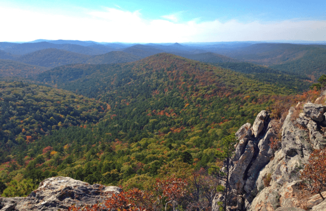
Here’s something that’ll impress your geologist friends at the next dinner party: the Ouachita Mountains are one of only two major mountain ranges in the entire continental United States that run east to west. The other is the Brooks Range in Alaska. This orientation was caused by ancient continental collisions that compressed the earth’s crust horizontally rather than pushing it upward. The parallel ridges and valleys that resulted create a dramatic, almost rippled landscape that’s stunning from both the ground and the air.
A Brief History of the Ouachita Region
Mountains don’t exist in a vacuum. The Ouachitas have been home to people for thousands of years, and their story is as rich and layered as the geology beneath your boots.
Indigenous Roots and Early Settlers
Long before European explorers set foot in the region, the Ouachita Mountains were home to Indigenous peoples including the Caddo Nation. These were sophisticated communities that hunted, farmed, and traded across vast distances. When Spanish explorer Hernando de Soto and his expedition passed through the area in the 1540s, they encountered thriving Indigenous villages nestled in these hills.
French explorers followed in the 17th and 18th centuries, and the region eventually became part of the Louisiana Purchase in 1803. American settlers began pouring in shortly after, drawn by the promise of fertile valleys and abundant wildlife.
How the Mountains Got Their Name
The name “Ouachita” (pronounced WAH-shih-taw) is derived from a Native American word, though its exact origin is debated. Some historians trace it to a Caddo word meaning “good hunting grounds,” while others link it to a French adaptation of an Indigenous tribal name. Either way, the name stuck — and it perfectly captures the spirit of this wild, welcoming landscape.
The Natural Wonders You Simply Can’t Miss
Alright, let’s get to the good stuff. What makes the Ouachita Mountains worth the drive?
Ouachita National Forest: America’s Oldest and Largest Southern National Forest
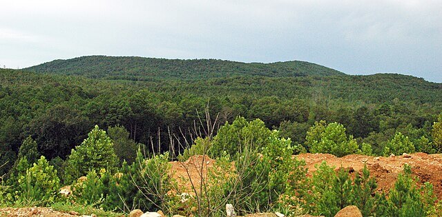
Established in 1907 under President Theodore Roosevelt, the Ouachita National Forest covers nearly 1.8 million acres across Arkansas and Oklahoma. It’s not just a forest — it’s an ecosystem on a grand scale. Dense hardwood forests, longleaf pine savannas, clear mountain streams, and quiet meadows make this one of the most biodiverse places in the entire South.
The forest is a playground for outdoor lovers. We’re talking hundreds of miles of hiking trails, dozens of campgrounds, mountain lakes, and scenic drives that’ll have you pulling over every five minutes just to soak it all in.
Hot Springs National Park: Where Nature Meets Luxury
If you’ve never soaked in a thermal bath fed by naturally heated groundwater in the middle of a national park, then you haven’t truly lived. Hot Springs National Park, located on the eastern edge of the Ouachitas, is one of the most unique parks in the entire U.S. National Park System.
The city of Hot Springs literally grew up around 47 thermal springs that pour out water at a steady 143°F. In the late 19th and early 20th centuries, this place was the Las Vegas of the South — drawing presidents, celebrities, and gangsters alike who came to “take the waters.” Today, you can still bathe in the thermal waters at historic bathhouses along the famous Bathhouse Row.
Crystal-Clear Lakes and Rivers
The Ouachita region is laced with stunning bodies of water. Lake Ouachita, the largest lake entirely within Arkansas, stretches over 40,000 acres and offers some of the clearest water you’ll find anywhere in the South. Lake Hamilton and Lake Catherine are equally gorgeous, making the region a paradise for boaters, anglers, and swimmers.
The Ouachita River itself winds through the heart of the mountains, offering excellent kayaking and canoeing opportunities for all skill levels.
Wildlife of the Ouachita Mountains
If you’re quiet enough and patient enough the Ouachita Mountains will put on a wildlife show you’ll never forget.
Flora: A Botanical Paradise
The forests here are a patchwork of shortleaf pine, loblolly pine, white oak, black oak, and hickory. In spring, the hillsides erupt with wildflowers: dogwood blossoms, trilliums, wild azaleas, and mountain laurel paint the ridges in shades of pink, white, and purple. It’s the kind of scene that makes you want to put your phone away and just look.
Fauna: Who’s Roaming These Ridges?
The Ouachitas support an impressive roster of wildlife. White-tailed deer are practically around every corner. Black bears roam the deeper forests yes, real black bears, though they’re generally more interested in berries than hikers. Wild turkeys strut through the underbrush, and if you’re lucky, you might spot a red-cockaded woodpecker, a rare and federally protected species that calls these pine forests home.
Birdwatchers will have a field day here. Over 200 species of birds have been recorded in the Ouachita National Forest, making it a premier destination for serious birders.
Top Outdoor Activities in the Ouachita Mountains
Here’s where the real fun begins. The Ouachitas aren’t just pretty to look at they’re built for adventure.
Hiking Trails That Will Take Your Breath Away
Whether you’re a seasoned thru-hiker or someone who considers a walk around the block a workout, the Ouachitas have a trail for you. From gentle nature walks to grueling multi-day backcountry routes, the options are almost endless.
The Ouachita National Recreation Trail
The crown jewel of Ouachita hiking is without a doubt the Ouachita National Recreation Trail (OHT). Stretching an impressive 223 miles from Talimena State Park in Oklahoma to Pinnacle Mountain State Park near Little Rock, Arkansas, this is one of the longest trails in the South. Thru-hikers typically complete it in 10 to 14 days, but the trail is dotted with access points that allow you to sample sections of any length.
The scenery along the OHT is consistently spectacular — rocky ridgelines with sweeping views, intimate creek crossings, and dense forest canopies that filter sunlight into golden shafts in the early morning.
Fishing, Kayaking, and Water Adventures
The Ouachita region is a water lover’s paradise. Lake Ouachita is famous for its trophy-size bass, catfish, and crappie. Several rivers and streams in the region are designated as Blue Ribbon trout fisheries, drawing fly-fishing enthusiasts from across the country.
For paddlers, the Caddo River and the Cossatot River offer everything from lazy flatwater floats to heart-pumping Class IV rapids. The Cossatot, in particular, is considered one of the most technically challenging whitewater rivers in the entire Midwest — it’s not for the faint of heart, but for experienced kayakers, it’s absolutely thrilling.
Camping Under a Sky Full of Stars
One of the most underrated experiences in the Ouachitas is simply spending a night under the stars. Light pollution is minimal in this part of the country, and on a clear night, the Milky Way is visible in all its glory. Whether you prefer a fully equipped campground with amenities or a remote backcountry site where the only sounds are wind and owls, the Ouachita National Forest has you covered.
Best Towns to Visit Near the Ouachita Mountains
The mountains themselves are wonderful, but the gateway towns add an extra layer of charm to any Ouachita adventure.
Hot Springs, Arkansas: The Crown Jewel
We’ve already touched on the national park, but the city of Hot Springs itself is an experience worth its own paragraph. Beyond the bathhouses, you’ll find a surprisingly vibrant arts scene, world-class dining, quirky museums, and a historic downtown that feels like stepping back in time. The city hosts the Hot Springs Documentary Film Festival each year — one of the oldest and most respected documentary film festivals in North America.
Mena, Arkansas: Small Town, Big Charm
Nestled in the heart of the Ouachitas along U.S. Highway 71, Mena is the kind of small town that feels frozen in the best possible way. It’s the gateway to the Talimena National Scenic Byway, a 54-mile highway that runs along the crests of the Ouachita ridges and offers some of the most spectacular fall foliage views in the entire South. Pack a picnic, roll down the windows, and just drive.
Tips for Planning Your Ouachita Mountains Trip
A little planning goes a long way when it comes to getting the most out of your Ouachita experience.
Best Time to Visit
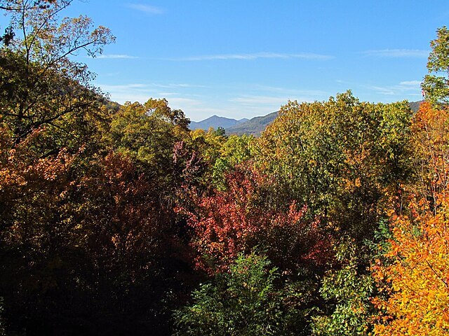
Fall — specifically October and early November — is the undisputed king of Ouachita seasons. The hardwood forests explode in shades of red, orange, and gold, and the weather is cool and crisp without being uncomfortable. Spring is a close second, when wildflowers bloom and the streams run full after winter rains. Summer can be hot and humid, but the lakes and rivers make it bearable. Winter visits are quieter and peaceful, with the occasional dusting of snow adding a magical quality to the ridgelines.
What to Pack and How to Prepare
Layering is essential in the Ouachitas, where temperatures can swing dramatically between morning and afternoon. Sturdy hiking boots, a good rain jacket, and plenty of water are non-negotiables. If you’re planning backcountry hiking, download offline maps because cell service can be spotty in the deeper hollows. And please — pack out what you pack in. These mountains are beautiful because people respect them.
Why the Ouachita Mountains Deserve More Recognition
Here’s the honest truth: the Ouachita Mountains are one of the most underrated destinations in the entire country. They don’t have the celebrity of the Rockies, the brand recognition of the Appalachians, or the dramatic skylines of the Sierra Nevada. But in many ways, that’s their greatest charm. You won’t find traffic jams on the Ouachita National Recreation Trail. You won’t have to book your campsite six months in advance. You’ll have space real, glorious, uninterrupted space — to breathe, explore, and reconnect with something bigger than yourself.
These mountains have been here for 300 million years. They’ll be patient with you. The question is: are you ready to finally show up?
Conclusion
The Ouachita Mountains are proof that you don’t have to travel to the ends of the earth to find something truly extraordinary. With ancient geology, rich Indigenous history, spectacular wildlife, world-class outdoor recreation, and charming gateway towns, this region offers a complete and deeply satisfying travel experience. Whether you’re lacing up your hiking boots for a 223-mile thru-hike or simply soaking in a century-old thermal bathhouse with a glass of sweet tea in hand, the Ouachitas have a way of getting under your skin — in the best possible way. So the next time someone asks you where you’re heading for your next adventure, surprise them. Say “Ouachita.” Then watch their curiosity light up.
FAQs
1. How do you correctly pronounce “Ouachita”?
Great question — it trips up almost everyone the first time. “Ouachita” is pronounced WAH-shih-taw. The “Ou” is silent, which throws most people off. Once you know it, you’ll say it confidently forever.
2. Are the Ouachita Mountains good for beginner hikers?
Absolutely! While the Ouachita National Recreation Trail is a serious undertaking for thru-hikers, there are dozens of shorter, well-maintained trails perfect for beginners and families. Trails around Lake Ouachita and near Hot Springs are especially beginner-friendly.
3. Is it safe to swim in Lake Ouachita?
Yes, Lake Ouachita is considered one of the cleanest lakes in the United States and is very popular for swimming, snorkeling, and scuba diving thanks to its exceptional water clarity. Always check current conditions before you go.
4. Can you see black bears in the Ouachita Mountains?
Yes, black bears do inhabit the deeper forests of the Ouachita National Forest, particularly in Arkansas. Bear encounters are relatively rare and bears typically avoid humans, but you should always follow proper food storage protocols when camping and never approach a bear in the wild.
5. What is the best scenic drive in the Ouachita Mountains?
The Talimena National Scenic Byway is widely considered the best scenic drive in the region. This 54-mile highway travels along the ridgeline crests between Mena, Arkansas, and Talihina, Oklahoma, offering sweeping panoramic views — especially breathtaking during fall foliage season in October.