
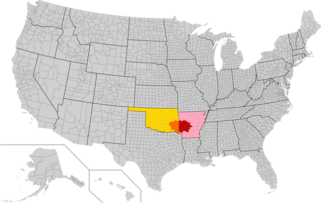
Have you ever wondered where you can find ancient mountains older than the Appalachians, crystal-clear lakes, and some of the most pristine wilderness in the American South? Look no further than Arkansas’s Ouachita Mountains – a spectacular mountain range that stretches across Arkansas and Oklahoma, offering outdoor enthusiasts an untouched paradise that rivals any destination in the country.
The Ouachita Mountains represent one of America’s best-kept secrets, combining breathtaking natural beauty with rich cultural heritage and endless outdoor adventures. Whether you’re a seasoned hiker, casual nature lover, or someone seeking a peaceful escape from city life, this ancient mountain range has something extraordinary waiting for you.
What Makes the Ouachita Mountains Special?
The Ouachita Mountains aren’t just another pretty mountain range – they’re a geological marvel with a fascinating story that spans hundreds of millions of years. These mountains hold secrets that make them unique among North American mountain systems, and understanding what makes them special will deepen your appreciation for every trail you hike and every vista you encounter.
Geological Wonder and Unique East-West Ridge Formation
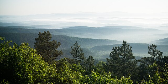
Unlike most mountain ranges in North America that run north-south, the Ouachita Mountains stretch east-west, creating a distinctive landscape that’s immediately recognizable to geologists and nature enthusiasts alike. These mountains formed approximately 300 million years ago during the collision of ancient continents, making them significantly older than the Rocky Mountains and even predating the Appalachians by millions of years.
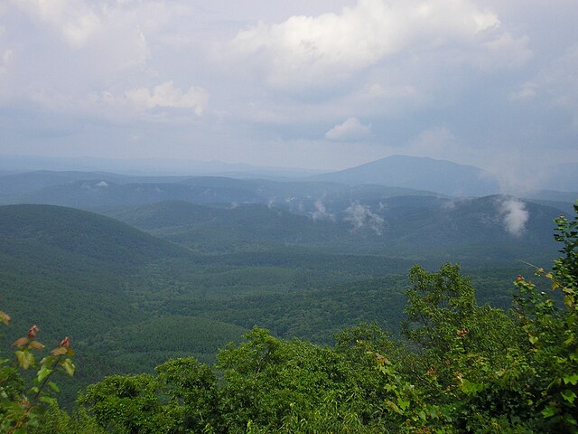
The unique geological formation creates parallel ridges and valleys that run perpendicular to most other American mountain systems. This east-west orientation means you’ll experience different microclimates and ecosystems as you travel from ridge to valley, creating an incredibly diverse natural environment within a relatively compact area.
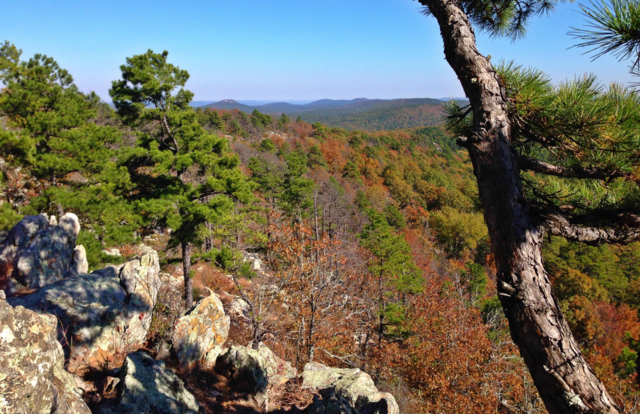
The mountains are primarily composed of folded and faulted sedimentary rocks, including sandstone, shale, and chert. This composition has created the perfect conditions for crystal-clear springs, deep valleys, and the distinctive ridgeline views that make the Ouachitas so photogenic.
Rich Cultural Heritage and Native American History
Long before European settlers arrived, the Ouachita Mountains were home to various Native American tribes, including the Caddo, Quapaw, and Osage peoples. The name “Ouachita” itself comes from the Caddo word “washita,” meaning “good hunting grounds” – a testament to the area’s abundant wildlife and natural resources.
The mountains played a crucial role in early American history, serving as a natural boundary and highway for explorers, traders, and settlers. French explorers navigated the Ouachita River in the early 1700s, and the region became an important source of minerals, timber, and other natural resources during America’s westward expansion.
Today, you can still find remnants of this rich history throughout the mountains, from ancient Native American sites to 19th-century mining operations and early settler homesteads. Many trails incorporate historical interpretive elements, allowing modern visitors to connect with the human stories that have unfolded in these mountains over centuries.
Planning Your Ouachita Mountains Adventure
Planning the perfect Ouachita Mountains experience requires understanding the region’s seasonal patterns, knowing what gear to bring, and having realistic expectations about what you’ll encounter. The key to a successful trip lies in matching your adventure level with the mountain’s offerings while respecting the natural environment that makes this region so special.
Best Time to Visit the Ouachita Mountains
The Ouachita Mountains offer year-round recreation opportunities, but each season brings distinct advantages and challenges that will influence your experience. Understanding these seasonal differences will help you plan the perfect trip based on your interests and comfort level.
Spring (March through May) is arguably the most magical time to visit the Ouachitas. The weather is mild with temperatures ranging from 60-75°F, wildflowers bloom throughout the forests and meadows, and waterfalls are at their most dramatic following winter rains. This season offers excellent hiking conditions, though you should be prepared for occasional rain showers and muddy trails.
Summer (June through August) brings hot, humid weather with temperatures often reaching 85-95°F, but also offers the longest days for extended adventures. Early morning and evening activities are most comfortable, and the numerous lakes provide perfect relief from the heat. Summer is ideal for water activities, camping, and wildlife watching, though you’ll want to carry plenty of water and start your hikes early.
Fall (September through November) transforms the Ouachitas into a painter’s palette of reds, oranges, and yellows. Temperatures cool to comfortable 55-75°F ranges, humidity drops significantly, and clear skies provide excellent visibility for photography and scenic drives. This is peak season for many visitors, so popular areas may be more crowded, but the spectacular foliage makes it worth the extra company.
Winter (December through February) offers a different kind of beauty, with bare trees revealing hidden rock formations and distant views obscured during leafier seasons. Temperatures range from 35-55°F, occasional ice storms can make travel challenging, but you’ll have most trails to yourself and experience the mountains in their most pristine state.
Essential Gear for Mountain Exploration
Proper preparation can make the difference between a memorable adventure and a difficult experience in the Ouachitas. The key is balancing lightweight efficiency with safety and comfort, especially since mountain weather can change quickly and help may be far away on remote trails.
Your basic gear should include sturdy hiking boots with good ankle support, as many Ouachita trails feature rocky terrain and creek crossings. Layered clothing is essential – temperatures can vary significantly between valleys and ridgetops, and weather conditions can change rapidly throughout the day.
Navigation equipment is crucial, even on well-marked trails. Carry a detailed topographic map, compass, and GPS device or smartphone with offline maps downloaded. Cell phone coverage can be spotty in remote areas, so don’t rely solely on your phone for navigation or emergency communication.
Safety equipment should include a first aid kit, emergency whistle, headlamp or flashlight with extra batteries, and emergency shelter such as a space blanket. If you’re planning overnight trips, add appropriate camping gear rated for expected temperatures and weather conditions.
Water is critically important in the Ouachitas, especially during summer months. Carry more water than you think you’ll need, and consider bringing water purification tablets or a portable filter if you’ll be near natural water sources. Many springs and streams in the Ouachitas are clean, but it’s always safer to purify water from any natural source.
Top Hiking Trails in the Ouachita Mountains
The Ouachita Mountains offer some of the most diverse and rewarding hiking experiences in the American South, with trails ranging from easy family-friendly walks to challenging multi-day backpacking adventures. These trails showcase everything that makes the Ouachitas special – from ancient geological formations to pristine wilderness areas that feel worlds away from civilization.
Ouachita National Recreation Trail
The Ouachita National Recreation Trail represents the crown jewel of Ouachita Mountains hiking – a 223-mile trail that stretches from Talihina, Oklahoma, to Pinnacle Mountain State Park near Little Rock, Arkansas. This trail offers the most comprehensive Ouachita Mountains experience possible, crossing every major ecosystem and geological formation in the range.
Don’t worry if 223 miles sounds intimidating – the trail is designed with multiple access points and can be hiked in sections ranging from day hikes to weekend backpacking trips. Each section offers unique features and difficulty levels, allowing you to customize your experience based on your fitness level and available time.
The trail’s western sections near the Oklahoma border feature the highest elevations and most dramatic vistas, including views from Rich Mountain and Winding Stair Mountain that stretch for miles across forested valleys. The central sections pass through classic Ouachita ridge-and-valley terrain, with frequent creek crossings and opportunities to explore hidden waterfalls and swimming holes.
Eastern sections of the trail offer easier hiking with more developed facilities, making them perfect for families or hikers new to the Ouachitas. These sections showcase the region’s cultural history, passing near historic sites and through areas where you can still see evidence of early settlement and industry.
Trail conditions vary significantly throughout the year and between sections. Spring brings muddy conditions but spectacular wildflowers, summer offers long days but requires careful attention to hydration, fall provides the best overall hiking conditions, and winter offers solitude but requires careful preparation for potentially icy conditions.
Caddo River Trail
The Caddo River Trail offers one of the most accessible yet rewarding hiking experiences in the Ouachitas, combining moderate difficulty with spectacular scenery and interesting cultural history. This trail follows portions of the pristine Caddo River, offering multiple opportunities for photography, wildlife watching, and simply enjoying one of Arkansas’s most beautiful waterways.
The trail features several interconnected loops and out-and-back sections, allowing hikers to customize their experience from short 2-mile walks to full-day 12-mile adventures. The terrain is generally moderate, with some steep sections that reward hikers with excellent river views and access to secluded swimming holes that provide perfect rest stops during warm weather.
What makes the Caddo River Trail special is its combination of natural beauty and accessibility. The trail passes through diverse ecosystems, from bottomland hardwood forests along the river to upland oak-hickory forests on the ridges. This diversity means you’ll encounter different wildlife, plant communities, and scenic opportunities within a single hike.
The river itself is remarkably clear and clean, fed by numerous springs throughout the watershed. During normal water levels, you’ll find excellent opportunities for wading, swimming, and simply cooling off during hot summer hikes. The trail includes several excellent spots for lunch breaks or extended rest stops where you can listen to the water flow over ancient rock formations.
Trail Difficulty and What to Expect
The Caddo River Trail is rated as moderate difficulty, making it accessible to most hikers with basic fitness levels while still providing enough challenge to feel rewarding. The trail includes approximately 800 feet of total elevation gain spread over rolling terrain, with no single climb being particularly demanding.
Expect to encounter several creek crossings that may require rock-hopping or wading, depending on recent rainfall. These crossings are generally safe but can be slippery, so take your time and use trekking poles if you have them. During high water periods, some crossings may be difficult or dangerous – check current conditions before your hike.
The trail is well-marked with standard forest service blazes, but carrying a map is still recommended since some side trails and old logging roads can be confusing. Most hikers complete the full trail loop in 4-6 hours, including stops for rest, photography, and enjoying the river.
Wildlife encounters are common along the Caddo River Trail, particularly early in the morning or late in the afternoon. You may see white-tailed deer, wild turkeys, various bird species, and occasionally black bears. Follow standard wildlife safety practices, including proper food storage and maintaining appropriate distances from any animals you encounter.
Eagle Rock Loop
The Eagle Rock Loop stands out as one of the most challenging and rewarding multi-day hiking experiences in the Ouachita Mountains, offering serious backpackers a chance to experience the region’s most remote and pristine wilderness areas. This 26.8-mile loop combines spectacular scenery with physical challenge, creating an adventure that will test your skills while providing memories that last a lifetime.
The loop can be completed in 2-4 days depending on your pace and desire to explore side trails and scenic areas. Most hikers choose a 3-day itinerary that allows time for rest, photography, and simply soaking in the incredible natural beauty without feeling rushed.
The trail’s highlight is the namesake Eagle Rock, a dramatic bluff that provides panoramic views across the Little Missouri River valley and surrounding wilderness. The approach to Eagle Rock includes some of the most challenging terrain on the loop, but the views from the top make every step worthwhile. Early morning and late afternoon provide the best lighting for photography and the most comfortable temperatures for enjoying the vista.
Beyond Eagle Rock, the loop offers diverse terrain including creek valleys, ridgetop forests, and several smaller but equally impressive rock formations and overlooks. The trail crosses the Little Missouri River multiple times, providing opportunities for water resupply, cooling off, and camping near the sound of flowing water.
Water sources are generally reliable along the Eagle Rock Loop, but conditions can vary seasonally. Spring and early summer provide the most consistent water availability, while late summer and fall may require more careful planning between water sources. Always purify water from natural sources, regardless of how clean it appears.
Crystal Clear Lakes and Water Activities
The Ouachita Mountains are home to some of Arkansas’s most pristine and beautiful lakes, offering visitors perfect opportunities to cool off, enjoy water sports, or simply relax beside crystal-clear waters surrounded by forested mountains. These lakes represent some of the cleanest and most scenic water bodies in the American South, each offering unique characteristics and recreational opportunities.
Lake Ouachita State Park
Lake Ouachita stands as Arkansas’s largest lake and one of the cleanest lakes in the United States, covering 40,000 acres with 975 miles of shoreline nestled among the Ouachita Mountains. This massive lake offers every imaginable water activity while maintaining remarkable water clarity that allows you to see 15-20 feet deep in many areas.
The lake was created by the construction of Blakely Mountain Dam in 1953, but rather than diminishing the natural beauty, the lake has become an integral part of the Ouachita Mountains ecosystem. The clear, deep waters support excellent fish populations, while the forested shoreline provides habitat for wildlife and creates stunning scenic backdrops for all water activities.
Lake Ouachita State Park, located on the lake’s eastern shore, serves as the primary gateway for visitors and offers comprehensive facilities including boat ramps, swimming areas, hiking trails, and camping facilities. The park’s location provides easy access to both developed recreation areas and remote coves where you can find solitude even during busy summer weekends.
What makes Lake Ouachita special is its remarkable water quality. The lake consistently ranks among the cleanest lakes in Arkansas, with excellent visibility and water that’s safe for swimming, skiing, and other contact activities. The clarity comes from the lake’s depth (up to 200 feet in some areas) and the relatively undeveloped watershed that feeds it.
Swimming at Lake Ouachita is exceptional, with designated swimming areas at the state park and numerous secluded coves accessible by boat or hiking trails. The clear water allows you to see exactly where you’re swimming, and the mountain setting provides a much more scenic experience than typical lake swimming.
Fishing and Boating Opportunities
Lake Ouachita offers some of the finest freshwater fishing in Arkansas, supporting healthy populations of largemouth bass, striped bass, white bass, catfish, bream, and crappie. The lake’s size and depth create diverse fishing environments, from shallow coves perfect for bass fishing to deep-water areas where striped bass and other pelagic species thrive.
The lake’s structure includes numerous underwater points, drop-offs, and submerged timber that create excellent fish habitat. Local fishing guides report consistent success throughout the year, with spring and fall offering the most productive fishing as fish move into shallow water areas that are accessible to shore anglers and small boat fishermen.
Boating on Lake Ouachita provides access to hundreds of coves and remote areas that would be difficult or impossible to reach on foot. The lake’s size means you can spend days exploring different areas, each offering unique scenery and recreational opportunities. Several full-service marinas provide boat rentals, fuel, and supplies for extended lake adventures.
The combination of clean water, scenic beauty, and excellent facilities makes Lake Ouachita ideal for all types of boating, from high-performance water skiing to peaceful canoeing or kayaking. The lake’s size means you can always find areas appropriate for your preferred activities, whether you want high-speed excitement or quiet paddling through secluded coves.
DeGray Lake Resort State Park
DeGray Lake offers a more intimate lake experience than massive Lake Ouachita, covering 13,800 acres with a focus on providing luxury accommodations alongside excellent water recreation opportunities. The lake and surrounding state park represent Arkansas’s premier destination for visitors who want to combine outdoor adventure with comfortable lodging and dining.
The lake was created by DeGray Dam on the Caddo River in 1972, flooding a valley that now provides excellent fishing and water recreation opportunities. The relatively young age of the lake means less accumulated sediment and excellent water clarity, while the controlled water levels ensure consistent recreation opportunities throughout the year.
DeGray Lake Resort State Park features Arkansas’s only resort lodge located on a lake island, accessible by a short causeway that creates the feeling of being completely surrounded by water. The lodge offers upscale accommodations, dining, and conference facilities while maintaining easy access to all lake activities and mountain hiking trails.
The lake’s smaller size compared to Lake Ouachita creates a more intimate feel while still offering plenty of room for all water activities. The protected coves and bays provide excellent areas for beginning water skiers, while the main lake areas offer enough space for experienced boaters to enjoy high-speed activities.
Fishing at DeGray Lake focuses primarily on largemouth bass, with the lake producing numerous tournament-quality fish each year. The lake’s structure includes standing timber, creek channels, and rock formations that provide excellent fish habitat and make for interesting and productive fishing experiences.
Scenic Drives Through Ancient Mountains
The Ouachita Mountains offer some of the most spectacular scenic driving experiences in the American South, with winding mountain roads that reveal new vistas around every curve. These drives provide perfect opportunities for photographers, families with young children, or anyone who wants to experience the mountains’ beauty without the physical demands of hiking.
Talimena Scenic Drive
The Talimena Scenic Drive represents the crown jewel of Ouachita Mountains scenic driving, stretching 54 miles along the crest of Rich Mountain and Winding Stair Mountain between Talihina, Oklahoma, and Mena, Arkansas. This designated National Scenic Byway offers continuous mountain vistas, interpretive stops, and access to numerous hiking trails and recreation areas.
The drive follows ancient ridge lines, maintaining elevations between 2,000 and 2,681 feet (at Rich Mountain, the second-highest peak in Arkansas) for most of its length. This elevated route provides consistent panoramic views across forested valleys and distant mountain ridges, with visibility extending for 40-50 miles on clear days.
What makes the Talimena Drive special is its accessibility – you can experience the most dramatic Ouachita Mountains scenery from the comfort of your vehicle, making it perfect for families, elderly visitors, or anyone with mobility limitations. However, the drive also provides access to some of the region’s most challenging hiking trails and remote wilderness areas for those seeking more adventurous experiences.
The drive includes numerous pullouts and interpretive stops where you can safely exit your vehicle, read about local ecology and history, and take photographs. These stops are strategically located at the most scenic viewpoints and provide information about the geological processes that created these ancient mountains.
Fall foliage season (typically mid-October through early November) transforms the Talimena Drive into one of America’s premier autumn scenic drives. The combination of elevation changes, diverse tree species, and consistent viewpoints creates spectacular color displays that rival any autumn destination in the country.
Arkansas Highway 7
Arkansas Highway 7 through the Ouachita Mountains offers a different but equally rewarding scenic driving experience, following valleys and crossing ridges between Hot Springs and Harrison, Arkansas. This route provides intimate views of mountain communities, pristine rivers, and the kind of Ozark Mountain scenery that defines rural Arkansas character.
The southern portion of Highway 7 passes through classic Ouachita Mountains terrain, including crossings of the Caddo River, South Fork River, and numerous smaller streams that create the clear, spring-fed waterways for which the region is famous. These river crossings often include small parks or informal stopping areas where you can stretch your legs and enjoy the water.
Unlike the ridge-top route of the Talimena Drive, Highway 7 follows natural contours through valleys and over mountain passes, creating a more varied driving experience with constantly changing scenery. You’ll pass through small mountain communities that preserve traditional Ouachita Mountains culture, including local craft shops, cafes, and historic sites.
The route includes several worthwhile stops, including Buffalo Point on the Buffalo National River (technically in the Ozarks but easily accessible from the Ouachitas), historic Jasper, and numerous access points for hiking trails, fishing areas, and camping facilities.
This drive is particularly beautiful during spring when redbuds and dogwoods bloom throughout the forests, creating natural bouquets against the backdrop of new green leaves. The route is also excellent during fall foliage season, offering more intimate views of autumn colors than the expansive vistas along the Talimena Drive.
Wildlife Watching and Natural Photography
The Ouachita Mountains support diverse wildlife populations in largely intact ecosystems, making the region excellent for wildlife watching and nature photography. The combination of minimal human development, diverse habitats, and careful wildlife management has created conditions where native species thrive and visitors can observe animals in natural settings.
Black Bear Habitat and Safety Tips
The Ouachita Mountains are home to a healthy and growing black bear population, with recent estimates suggesting 4,000-6,000 bears throughout Arkansas, with significant concentrations in the Ouachita and Ozark Mountains. While bear encounters are relatively rare, understanding bear behavior and safety practices will help you enjoy the mountains safely while contributing to bear conservation.
Black bears in the Ouachitas are generally smaller than their northern cousins, with adult males typically weighing 200-400 pounds and females weighing 150-250 pounds. They are omnivores with diets consisting primarily of berries, nuts, insects, and vegetation, though they will opportunistically eat fish, small mammals, and carrion when available.
Bear activity varies significantly by season, with bears most active during spring (March-May) as they emerge from winter dens and search for food after months of fasting. Summer activity focuses on berry patches and water sources, while fall finds bears concentrating on acorn and nut crops as they prepare for winter denning.
The key to safe bear encounters is prevention through proper food storage and camp hygiene. Always store food, toiletries, and scented items in bear-proof containers or hang them at least 12 feet high and 6 feet from tree trunks. Keep campsites clean, never feed bears or leave food scraps, and dispose of garbage properly in designated containers.
If you encounter a bear, remain calm and do not run. Make yourself appear large, back away slowly while facing the bear, and speak in calm, loud tones. Most bears will leave the area once they detect humans. Give bears plenty of space – observe from at least 100 yards away and never approach cubs, as mother bears are particularly protective.
Photography of black bears can be incredibly rewarding, but requires telephoto lenses and careful attention to safety. Early morning and late evening provide the best opportunities for bear photography, particularly near berry patches, water sources, and forest edges where bears commonly feed.
Bird Watching Hotspots
The Ouachita Mountains’ diverse habitats support over 180 bird species throughout the year, making the region excellent for both casual bird watching and serious birding expeditions. The combination of forest types, elevation changes, and water features creates microhabitats that attract different species and provide year-round birding opportunities.
Spring migration (April-May) brings the most dramatic birding experiences, with numerous neo-tropical migrants passing through or establishing breeding territories in the mountains. Warblers, vireos, flycatchers, and thrushes fill the forests with color and song, creating some of the finest birding experiences in Arkansas.
The region’s diverse forest communities support different bird species at different elevations and in different habitat types. Oak-hickory forests on the ridges provide habitat for woodpeckers, nuthatches, and forest raptors, while bottomland hardwood areas along streams support different communities including kingfishers, herons, and water-associated species.
Several locations offer particularly excellent birding opportunities. Hot Springs National Park, while small, includes diverse habitats and maintained trails that make bird observation easy. Lake Ouachita and DeGray Lake provide excellent waterfowl and water bird watching, particularly during migration periods when numerous species stop to rest and feed.
Early morning (dawn to 9 AM) provides the best birding opportunities when most species are most active and vocal. Bringing binoculars is essential, and a good field guide to Arkansas birds will help you identify the numerous species you’re likely to encounter.
Photography of birds in the Ouachitas can be challenging but rewarding, requiring patience, telephoto lenses, and understanding of bird behavior. Many species are approachable if you move slowly and avoid sudden movements, while others require observation from greater distances or specialized techniques like blind photography.
Camping and Accommodation Options
The Ouachita Mountains offer camping and accommodation options for every preference and budget, from primitive backcountry sites where you’ll hear nothing but natural sounds to full-service lodges with resort amenities. Understanding your options will help you choose the perfect base for your mountain adventures.
Primitive Camping in National Forest
The Ouachita National Forest encompasses over 1.8 million acres across Arkansas and Oklahoma, with most areas open to dispersed camping that provides the ultimate wilderness experience. Primitive camping allows you to establish your own campsite in natural settings, often with complete privacy and minimal impact on the environment.
Dispersed camping is allowed throughout most of the national forest, with few restrictions beyond basic Leave No Trace principles and safety considerations. You must camp at least 100 feet from water sources, established trails, and roads, and you cannot stay in the same location for more than 14 days.
The freedom of primitive camping allows you to wake up beside mountain streams, on ridge tops with panoramic views, or in secluded valleys where your only neighbors are wildlife. This style of camping requires more preparation and self-sufficiency but provides unmatched connection with the natural environment.
When primitive camping, you must bring all necessary water or have reliable purification methods, as natural water sources require treatment before drinking. Campfires are allowed in most areas during safe conditions, but you should check current fire restrictions and always follow fire safety practices including completely extinguishing all fires.
Popular primitive camping areas include the remote sections along the Ouachita National Recreation Trail, areas accessible from forest service roads near the Caddo River, and elevated sites near the Oklahoma border that provide excellent sunrise and sunset viewing opportunities.
State Park Lodges and Cabins
For visitors who prefer more comfortable accommodations without sacrificing access to mountain adventures, Arkansas’s state park system offers excellent lodges and cabins throughout the Ouachita Mountains. These facilities provide modern amenities while maintaining the natural character that makes the mountains special.
DeGray Lake Resort State Park offers the most luxurious accommodations, with a full-service lodge featuring comfortable rooms, restaurant, conference facilities, and marina services. The lodge’s island location creates a unique setting where you’re surrounded by water while maintaining easy access to mountain hiking trails and scenic drives.
Lake Ouachita State Park provides cabin rentals and camping facilities in a more natural setting, with accommodations ranging from basic camping cabins to fully equipped vacation rentals. The park’s location on the lake’s eastern shore provides excellent access to water activities while serving as a gateway to mountain trails and scenic areas.
Petit Jean State Park, while technically in the Arkansas River Valley rather than the core Ouachitas, offers excellent accommodations and serves as a perfect base for exploring the eastern portions of the mountain range. The park’s historic lodge and cabins provide comfortable accommodations with easy access to numerous hiking trails and scenic overlooks.
Many state park accommodations book well in advance, particularly during peak seasons like fall foliage and summer vacation periods. Making reservations several months ahead ensures availability and often provides better rates than last-minute bookings.
Local Culture and Mountain Communities
The Ouachita Mountains preserve traditional Arkansas mountain culture while adapting to modern tourism and economic opportunities. Understanding local culture enhances your visit by connecting you with the human stories that have shaped these mountains for generations.
Hot Springs National Park Connection
Hot Springs National Park, located on the eastern edge of the Ouachita Mountains, represents the intersection of natural wonders and human history that characterizes the entire region. While the park itself is small (5,550 acres), its cultural significance and connection to Ouachita Mountains geology make it an important part of any comprehensive mountain experience.
The hot springs that give the park its name result from the same geological processes that created the Ouachita Mountains, with groundwater heated by contact with deep rock formations emerging at temperatures around 143°F. Native Americans considered these springs sacred and neutral territory where different tribes could gather peacefully for healing and trade.
The development of Hot Springs as a resort destination in the late 1800s and early 1900s created the infrastructure and cultural traditions that continue to influence the entire Ouachita Mountains region. The grand bathhouses, historic hotels, and tourism industry established patterns that shaped how the mountains are experienced and preserved today.
Modern Hot Springs combines historic preservation with contemporary attractions, including renovated bathhouses, hiking trails throughout the mountains surrounding the city, and cultural events that celebrate both natural heritage and human history. The city serves as an excellent base for exploring the broader Ouachita Mountains while providing comfortable accommodations and dining options.
Traditional Crafts and Local Artisans
The Ouachita Mountains maintain strong traditions of handcraft and artistic expression that reflect both practical mountain living and creative cultural heritage. These traditions provide insight into how mountain communities have adapted natural resources and developed distinctive cultural expressions over generations.
Traditional crafts include woodworking using native hardwoods like oak, hickory, and walnut that grow throughout the mountains. Local artisans create furniture, decorative items, and functional tools using techniques passed down through generations, often incorporating designs and methods that reflect both European settler traditions and Native American influences.
Pottery and ceramics utilize local clay deposits and traditional firing techniques, creating distinctive pieces that reflect the natural colors and textures of the mountain environment. Many potters incorporate natural materials like wood ash glazes and traditional forms that serve both functional and aesthetic purposes.
Textile arts including quilting, weaving, and traditional clothing construction remain active throughout mountain communities. These crafts often use patterns and techniques with deep historical roots while incorporating contemporary materials and designs that keep traditions alive and relevant.
Music represents perhaps the most visible aspect of Ouachita Mountains cultural traditions, with bluegrass, country, and folk music deeply embedded in community life. Many mountain communities host regular music events, festivals, and informal gatherings where traditional and contemporary mountain music creates social connections and cultural continuity.
Adventure Sports and Outdoor Activities
Beyond hiking and water activities, the Ouachita Mountains offer excellent opportunities for adventure sports that take advantage of the region’s unique geology and pristine natural environment. These activities provide exciting ways to experience the mountains while challenging your skills and providing different perspectives on familiar landscapes.
Rock Climbing and Bouldering
The Ouachita Mountains’ geological composition creates excellent rock climbing and bouldering opportunities, with sandstone and quartzite formations providing reliable holds and interesting route variations. While not as well-known as climbing areas in other regions, the Ouachitas offer quality climbing with minimal crowds and beautiful natural settings.
The region’s climbing focuses primarily on traditional and sport routes on natural rock formations, with most climbing areas accessible via moderate hikes that add adventure to the climbing experience. Routes range from beginner-friendly 5.3-5.5 grades to challenging 5.11+ routes that test experienced climbers.
Popular climbing areas include bluffs along the Buffalo River (technically in the adjacent Ozarks but easily accessible from the Ouachitas), formations near Rich Mountain, and numerous smaller crags throughout the national forest. Many climbing areas also offer excellent bouldering on high-quality stone with good landing zones.
The relatively undeveloped nature of Ouachita Mountains climbing means that route development and maintenance depend on climbing community involvement. Climbers should follow Leave No Trace principles, respect private property boundaries, and contribute to trail maintenance and route preservation efforts.
Access to climbing areas often involves hiking on forest service trails or cross-country navigation, requiring good map reading skills and wilderness preparation. Weather conditions can change rapidly in the mountains, making proper clothing and emergency preparation essential for safe climbing.
Mountain Biking Trails
The Ouachita Mountains offer some of Arkansas’s finest mountain biking, with trails ranging from gentle family-friendly rides to technical single track that challenges experienced riders. The combination of varied terrain, scenic beauty, and well-maintained trail systems makes the region increasingly popular among mountain biking enthusiasts.
The Ouachita National Recreation Trail includes several sections specifically designed for mountain biking, providing multi-day riding opportunities through pristine mountain wilderness. These sections offer challenging climbs, technical descents, and spectacular scenery while maintaining sustainable trail design that minimizes environmental impact.
Shorter trail systems near Lake Ouachita, DeGray Lake, and Hot Springs provide excellent day-ride opportunities with varied difficulty levels and convenient access to services and accommodations. These trails often include loop options that allow riders to customize their experience based on skill level and available time.
The region’s mountain biking infrastructure continues to develop, with local cycling groups and land management agencies working together to create sustainable trail systems that provide excellent riding while protecting natural resources. Many trails incorporate features like technical rock sections, creek crossings, and scenic overlooks that add interest and challenge to rides.
Trail conditions vary seasonally, with spring and fall generally providing the best riding conditions. Summer heat and humidity can make riding challenging during midday hours, while winter conditions may include ice and snow that make some trails dangerous or impassable.
Seasonal Attractions and Events
The Ouachita Mountains offer distinctly different experiences throughout the year, with each season bringing unique attractions, events, and natural phenomena that showcase different aspects of the region’s beauty and character. Understanding seasonal variations helps you plan visits that align with your interests and provide the most rewarding experiences.
Fall Foliage Tours
Fall foliage season transforms the Ouachita Mountains into one of the American South’s premier autumn destinations, typically reaching peak colors between mid-October and early November. The region’s diverse tree species, elevation changes, and extensive forest coverage create spectacular color displays that rival any autumn destination in North America.
The Ouachitas’ unique east-west orientation means that different elevations and exposures reach peak colors at slightly different times, extending the overall foliage season and providing multiple opportunities to experience peak conditions. Higher elevations and north-facing slopes typically change first, followed by valleys and south-facing slopes.
Key species contributing to fall color include sugar maple, red maple, black gum, sassafras, hickory, and oak varieties that create the classic palette of reds, oranges, yellows, and browns associated with spectacular autumn foliage. The region’s relatively stable climate means that color changes are gradual and predictable, though early frosts or severe weather can affect timing and intensity.
The Talimena Scenic Drive becomes the region’s premier foliage destination during peak season, offering continuous mountain vistas filled with autumn colors. Weekend traffic can be heavy during peak foliage periods, so plan for extra travel time and consider visiting during weekdays for a more peaceful experience.
Photography opportunities during foliage season are virtually unlimited, with scenic overlooks, forest trails, and lakeshores all providing excellent settings for capturing autumn colors. Early morning and late afternoon light enhances colors and creates dramatic shadows that add depth and interest to photographs.
Spring Wildflower Blooms
Spring in the Ouachita Mountains brings an explosion of wildflowers that transforms forest floors and meadows into natural gardens filled with color and fragrance. The extended spring season, typically lasting from late March through early June, provides numerous opportunities to experience different species and communities of wildflowers throughout the mountains.
The progression of spring bloom follows elevation and exposure patterns, with south-facing slopes and lower elevations blooming first, followed by higher elevations and protected areas that remain cool longer. This natural succession means that spring wildflower viewing opportunities extend over several months rather than occurring all at once.
Early spring species include bloodroot, trout lily, and various violets that often bloom while trees are still leafless, taking advantage of sunlight that reaches the forest floor before leaves emerge. These early bloomers create carpets of white, yellow, and purple flowers that contrast beautifully with brown leaves and bare branches.
Mid-spring brings the peak wildflower season, with species like wild azalea, dogwood, redbud, and numerous forest wildflowers creating spectacular displays throughout the mountains. This period typically coincides with mild weather and comfortable hiking conditions, making it ideal for extended wildflower photography and exploration.
Late spring extends into early summer with species like mountain laurel and various orchids providing continued interest for botanically-minded visitors. These later bloomers often occur in specialized habitats like bog areas or high-elevation sites that require more effort to reach but reward visitors with unique and beautiful species.
Wildflower identification guides specific to Arkansas or the southeastern United States enhance spring visits by helping you understand and appreciate the diversity of species you encounter. Many wildflowers have interesting ecological relationships, medicinal histories, or cultural significance that add depth to simple aesthetic appreciation.
Conclusion
The Ouachita Mountains represent one of America’s most underappreciated natural treasures, offering visitors an extraordinary combination of ancient geological wonders, pristine wilderness, diverse wildlife, and rich cultural heritage. From the crystal-clear waters of Lake Ouachita to the panoramic vistas along the Talimena Scenic Drive, from challenging backpacking adventures on the Ouachita National Recreation Trail to peaceful family camping at state parks, these mountains provide outdoor experiences that rival any destination in the country.
What makes the Ouachitas truly special is their accessibility combined with their wild character. You can drive scenic mountain roads that reveal spectacular vistas around every curve, then step onto hiking trails that lead into wilderness areas where the only sounds are wind, water, and wildlife. The region’s manageable size means you can experience incredible diversity within short distances, while the extensive public lands ensure that adventure opportunities will remain available for future generations.
Whether you’re seeking heart-pounding adventure sports, peaceful contemplation beside mountain streams, or educational experiences that connect you with natural and cultural history, the Ouachita Mountains deliver experiences that create lasting memories and deep appreciation for America’s natural heritage. The region’s seasonal variations mean that every visit offers something new, while the timeless character of these ancient mountains provides a stable foundation for adventure and discovery.
As you plan your Ouachita Mountains adventure, remember that the best experiences come from matching your expectations with the mountains’ offerings, preparing properly for the activities you choose, and approaching the natural environment with respect and curiosity. These mountains have stories to tell and beauty to share – your role is to listen, observe, and become part of the ongoing story that connects all visitors to this remarkable landscape.
The Ouachita Mountains are waiting for your discovery. Whether this is your first visit or your fiftieth return, these ancient peaks, clear waters, and pristine forests have new adventures and fresh perspectives ready to share. Pack your sense of wonder along with your hiking boots, and prepare to discover why the Ouachitas represent one of the South’s best-kept outdoor secrets.
Frequently Asked Questions (FAQs)
Q: What’s the best time of year to visit the Ouachita Mountains for hiking?
A: Fall (September through November) offers the best overall hiking conditions with comfortable temperatures (55-75°F), low humidity, spectacular foliage, and excellent trail conditions. Spring (March through May) is also excellent, featuring wildflowers and mild weather, though trails may be muddy. Summer provides the longest days but requires early starts due to heat and humidity.
Q: Are there dangerous animals in the Ouachita Mountains I should be concerned about?
A: The primary wildlife concern is black bears, which are present throughout the region but rarely cause problems when proper food storage and safety practices are followed. Venomous snakes including timber rattlesnakes and copperheads are present but encounters are uncommon. Ticks carrying various diseases are the most significant health concern, making insect repellent and daily tick checks essential.
Q: Can I camp anywhere in the Ouachita National Forest?
A: Yes, dispersed camping is allowed throughout most of the Ouachita National Forest with minimal restrictions. You must camp at least 100 feet from water sources, trails, and roads, and cannot stay in the same location for more than 14 days. Some areas near developed facilities or sensitive ecological sites may have camping restrictions, so check current regulations for your specific area.
Q: What’s the difference between the Ouachita Mountains and the Ozark Mountains?
A: The Ouachita Mountains run east-west across Arkansas and Oklahoma, while the Ozark Mountains run north-south through Arkansas, Missouri, and Oklahoma. The Ouachitas are older geologically and feature different rock formations, creating distinct landscapes and ecosystems. The Ouachitas tend to have higher elevations and more rugged terrain, while the Ozarks feature more plateau-like topography with deeply carved river valleys.
Q: Do I need permits for hiking or camping in the Ouachita Mountains?
A: No permits are required for day hiking or dispersed camping in the Ouachita National Forest. However, some state parks charge entrance fees, and developed campgrounds require reservations and fees. If you plan to fish, you’ll need appropriate Arkansas or Oklahoma fishing licenses. Some special events or group activities may require permits, so check with the relevant land management agency for specific activities.