
What Makes Chiricahua National Monument Special?
Tucked away in southeastern Arizona, Chiricahua National Monument stands as one of America’s most spectacular yet underappreciated natural treasures. This 12,025-acre wonderland showcases towering rock pinnacles, balanced rocks, and stone columns that seem to defy gravity itself. But what exactly makes this place so extraordinary?
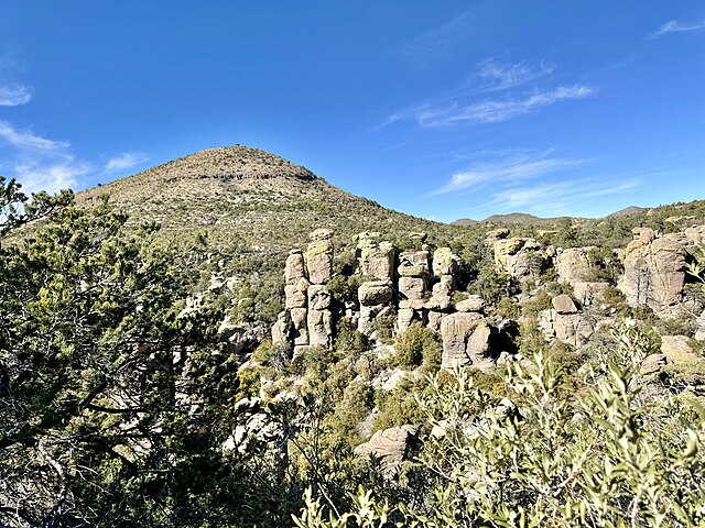
Picture walking through a natural cathedral where 200-foot-tall stone spires reach toward the sky like ancient monuments. The Chiricahua Mountains, often called the “Wonderland of Rocks,” offer visitors an otherworldly experience that feels more like exploring an alien landscape than hiking through Arizona desert.
The monument’s unique geological formations tell a story that began 27 million years ago, when massive volcanic eruptions created the Turkey Creek Caldera. Over millions of years, wind and water carved these volcanic deposits into the incredible rock sculptures we see today. It’s nature’s own art gallery, where every turn reveals new masterpieces sculpted by time itself.
The Fascinating Formation of Rock Pinnacles
How did these incredible rock formations come to be? The answer lies in one of the most violent geological events in Earth’s history. When the Turkey Creek Volcano erupted, it expelled over 1,000 times more material than Mount St. Helens did in 1980. This catastrophic event deposited layers of volcanic ash and rock fragments, called rhyolite tuff, that would eventually become the building blocks of today’s monument.
The real magic happened over the following millions of years. Water seeped into cracks in the rock, freezing and expanding during cold periods, gradually widening these fissures. Meanwhile, chemical weathering slowly dissolved certain minerals, creating the vertical joints and horizontal beds that define the monument’s signature pillars and balanced rocks.
What makes Chiricahua’s formations particularly striking is their vertical nature. Unlike many desert rock formations that create horizontal layers, these pinnacles shoot straight up from the ground like stone skyscrapers. Some balanced rocks appear so precariously positioned that you’ll wonder how they’ve remained stable for thousands of years.
Unique Wildlife and Biodiversity
The Chiricahua Mountains create what biologists call a “sky island” – a mountain range surrounded by desert that supports ecosystems typically found hundreds of miles to the north. This unique geographic position makes Chiricahua National Monument a biodiversity hotspot that’s home to an incredible variety of plant and animal species.
Over 200 bird species call this area home, including 14 different hummingbird species – more than anywhere else in the United States. The elegant trogon, a tropical bird rarely seen in the U.S., nests in the monument’s canyons. Mexican spotted owls, considered a threatened species, find sanctuary in the monument’s old-growth forests.
The monument’s elevation ranges from 5,400 to 7,310 feet, creating multiple climate zones within a relatively small area. Desert plants like prickly pear cactus grow alongside Douglas fir trees, while black bears and mountain lions roam the higher elevations. This incredible diversity makes every visit a potential wildlife encounter.
Rich Cultural and Historical Significance

Long before it became a national monument, these mountains held deep spiritual significance for the Apache people. The name “Chiricahua” itself comes from the Opata Indian word meaning “turkey mountain,” but for the Apache, these peaks represented much more than just geographical features.
Apache Heritage and Sacred Lands
The Chiricahua Apache, led by legendary figures like Cochise and Geronimo, considered these mountains their ancestral homeland. The rugged terrain provided perfect refuge during conflicts with U.S. forces in the late 1800s. Hidden canyons and secret water sources allowed Apache warriors to survive and resist encroachment on their traditional lands.
Today, visitors can still find remnants of Apache presence throughout the monument. Ancient pictographs adorn cave walls, while traditional plant gathering areas show evidence of centuries of sustainable use. The Apache understanding of this landscape’s resources – from medicinal plants to seasonal water sources – demonstrates a profound connection between people and place that lasted for generations.
The monument’s establishment in 1924 helped preserve not just geological formations but also the cultural landscape that holds such significance for Native American communities. Rangers and tribal members work together to ensure that traditional knowledge and cultural practices continue to be respected and shared with visitors.
Early Settlers and Ranching History
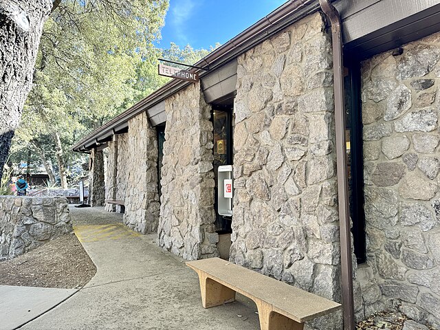
Following the Apache period, the late 1800s brought European-American settlers to the Chiricahua region. The Faraway Ranch, established by Neil and Emma Erickson in 1888, became a successful cattle operation that operated for over 60 years. The ranch buildings, now preserved as historic structures, tell the story of frontier life in southeastern Arizona.
The Ericksons weren’t just ranchers – they were early conservationists who recognized the unique beauty of the rock formations. They welcomed visitors and even guided early tourists through what they called their “Wonderland of Rocks.” Their efforts to promote the area’s natural beauty eventually contributed to its designation as a national monument.
Best Hiking Trails and Outdoor Activities
Chiricahua National Monument offers hiking experiences for every skill level, from easy nature walks to challenging mountain climbs. The trail system winds through diverse ecosystems, offering spectacular views of rock formations, wildlife spotting opportunities, and peaceful moments in pristine wilderness.
Echo Canyon Loop Trail
The Echo Canyon Loop Trail serves as the perfect introduction to Chiricahua’s wonders. This 3.3-mile moderate hike takes you through the heart of the rock formations, offering close-up views of balanced rocks, towering pinnacles, and narrow slot canyons.
The trail begins at the Echo Canyon parking area and immediately immerses you in a world of geological marvels. Wall Street, a narrow passage between towering rock walls, creates a cathedral-like atmosphere that photographers absolutely love. The acoustics here are remarkable – try clapping your hands and listen to the echo bounce between the stone walls.
As you continue along the loop, you’ll encounter formations with whimsical names like Duck on a Rock, Punch and Judy, and Totem Pole. Each formation tells part of the geological story, showing how water and wind carved these incredible shapes over millions of years.
Heart of Rocks Loop
For those seeking a more challenging adventure, the Heart of Rocks Loop combines several trails into a 7.4-mile journey through the monument’s most spectacular formations. This trail takes you to the very center of the rock wonderland, where some of the most iconic balanced rocks await.
The highlight of this hike is undoubtedly Balanced Rock, a massive boulder that appears to balance impossibly on a narrow pedestal. Thor’s Hammer, another famous formation, resembles a giant stone tool dropped by Norse gods. These formations provide incredible photo opportunities and showcase the amazing power of natural erosion.
The trail also passes through different ecological zones, from desert grasslands to pine forests. Spring wildflowers paint the landscape in vibrant colors, while fall brings golden aspens that contrast beautifully with the red rock formations.
Sugarloaf Mountain Trail
For hikers seeking panoramic views, the Sugarloaf Mountain Trail offers the monument’s most rewarding vista. This 3.4-mile round trip hike climbs 1,000 feet to the summit, where 360-degree views reveal the full scope of the Chiricahua Mountains.
From the summit, you can see the Dragoon Mountains to the west, the Peloncillo Mountains to the east, and Mexico’s Sierra Madre to the south. The view encompasses thousands of square miles of desert landscape, punctuated by other sky island mountain ranges that create a dramatic horizon.
The trail itself winds through different plant communities, from desert scrub at the base to pine and oak forests near the summit. Early morning hikers often spot deer, javelinas, and various bird species taking advantage of cooler temperatures.
Bird Watching and Wildlife Photography
Chiricahua National Monument ranks among North America’s premier bird watching destinations. The combination of diverse habitats and the monument’s location along major migration routes creates exceptional opportunities for both casual observers and serious birders.
The visitor center maintains a current bird list that often exceeds 100 species during peak migration periods. Hummingbird feeders attract multiple species, including broad-billed, blue-throated, and magnificent hummingbirds. The rare elegant trogon nests in the monument’s canyons, while Mexican spotted owls call from hidden perches.
Wildlife photographers find endless subjects throughout the monument. Coatimundis, ring-tailed cats, and black bears provide exciting mammal encounters, while reptiles like twin-spotted rattlesnakes and ornate box turtles add to the diversity. The key to successful wildlife photography here is patience and early morning visits when animals are most active.
When to Visit Chiricahua National Monument
Timing your visit to Chiricahua National Monument can make the difference between a good experience and an unforgettable one. The monument’s high elevation creates a temperate climate that’s generally pleasant year-round, but each season offers unique advantages for different types of visitors.
Spring: Wildflowers and Mild Weather
Spring, particularly March through May, brings some of the most spectacular displays of wildflowers in the American Southwest. Desert marigolds, fairy dusters, and prickly pear cacti create colorful carpets across the landscape. Higher elevations showcase lupines, paintbrush, and dozens of other mountain wildflowers.
The weather during spring is nearly perfect for hiking, with daytime temperatures typically ranging from 65-75°F and cool, comfortable nights. This is also peak bird migration season, making it ideal for wildlife enthusiasts. However, spring is also the monument’s busiest season, so expect more crowded trails and campgrounds.
Fall: Perfect Temperatures and Clear Skies
Many experienced visitors consider fall the absolute best time to visit Chiricahua. September through November offers crisp, clear days with excellent visibility for photography and panoramic views. Daytime temperatures remain comfortable for hiking, while cool nights make camping particularly enjoyable.
Fall also brings migrating birds back through the area, offering another excellent opportunity for bird watching. The changing leaves on oak and maple trees create beautiful contrasts against the red rock formations, making this season particularly rewarding for photographers.
Winter and Summer Considerations
Winter at Chiricahua can be quite cold, with temperatures dropping below freezing at higher elevations. However, winter also offers unique advantages: fewer crowds, dramatic weather patterns, and occasional snow that transforms the rock formations into winter wonderlands.
Summer temperatures can be challenging, especially at lower elevations. However, the monument’s elevation keeps it cooler than surrounding desert areas, and afternoon thunderstorms often provide relief from heat. Summer is also prime time for seeing baby wildlife and enjoying the monument’s seasonal water sources.
Where to Stay and Camping Options
Accommodation options around Chiricahua National Monument range from primitive camping to comfortable lodges, though the remote location means you’ll need to plan ahead for any type of overnight stay.
Bonita Canyon Campground
The monument’s only campground, Bonita Canyon, offers 25 sites nestled among oak trees in a scenic canyon setting. Sites accommodate both tents and RVs up to 29 feet long, though no hookups are available. The campground operates on a first-come, first-served basis, so arrival early in the day is essential during peak seasons.
Each site includes a picnic table, fire ring, and access to restrooms with flush toilets. The campground’s elevation at 5,400 feet keeps temperatures moderate even during summer months. The proximity to trailheads makes this an ideal base camp for exploring the monument’s hiking trails.
What makes Bonita Canyon Campground special is its natural setting. Oak trees provide shade during the day, while the absence of light pollution creates incredible stargazing opportunities. The sounds of canyon wrens and other birds provide a natural soundtrack that beats any city noise.
Nearby Accommodations
For those preferring more comfortable accommodations, several options exist within reasonable driving distance of the monument. The town of Willcox, about 37 miles away, offers several hotels and motels that cater to monument visitors.
Closer to the monument, the Portal Store and Lodge provides basic accommodations in a tiny community that serves as a gateway to the Chiricahua Mountains. This historic lodge offers a unique experience for visitors seeking a more authentic connection to the area’s frontier heritage.
Many visitors also choose to stay in Bisbee, about 90 minutes away, which offers a wider variety of accommodations plus the bonus of exploring a historic mining town. The drive from Bisbee to Chiricahua takes you through diverse landscapes that showcase the beauty of southeastern Arizona.
Planning Your Visit: Tips and Essentials

Success at Chiricahua National Monument depends largely on proper planning. The monument’s remote location and limited services mean that preparation is key to enjoying your visit safely and comfortably.
Getting There and Transportation
Chiricahua National Monument is located in southeastern Arizona, about 120 miles from Tucson and 37 miles from Willcox. The monument is accessible via Highway 186, which connects to Interstate 10 at Willcox. The final 8 miles to the visitor center follow Bonita Canyon Drive, a scenic but winding mountain road.
The nearest commercial airport is in Tucson, making a rental car essential for most visitors. The drive from Tucson takes about 2.5 hours and passes through diverse landscapes including desert valleys, grasslands, and mountain foothills.
Public transportation to the monument is extremely limited, so personal vehicles are essentially required. The roads within the monument are paved but steep and winding, so drive carefully and be prepared for switchbacks and narrow passages.
What to Pack and Bring
Packing for Chiricahua requires consideration of the monument’s elevation, remote location, and variable weather conditions. Essential items include plenty of water (at least one gallon per person per day), sun protection, and layers for changing temperatures.
Hiking boots with good ankle support are crucial for navigating rocky trails safely. The monument’s volcanic rock can be sharp and uneven, making proper footwear essential for injury prevention. Trekking poles can also be helpful for maintaining balance on steep sections.
Don’t forget your camera and extra batteries – the monument’s incredible rock formations and wildlife provide endless photo opportunities. Binoculars are essential for bird watching and spotting wildlife at a distance. A detailed map and compass or GPS device are also recommended, as cell phone service is limited throughout the monument.
Conclusion
Chiricahua National Monument stands as one of Arizona’s most remarkable yet underappreciated natural treasures. From its towering rock pinnacles and balanced boulders to its rich Apache heritage and incredible biodiversity, this geological wonderland offers experiences that few other places can match.
Whether you’re drawn by the challenging hiking trails, the exceptional bird watching opportunities, or simply the peaceful solitude of this remote wilderness, Chiricahua rewards every visitor with memories that last a lifetime. The monument’s unique combination of geological wonders, cultural significance, and natural beauty creates an experience that speaks to something deep within the human spirit.
As you plan your visit to this incredible destination, remember that Chiricahua National Monument is more than just a collection of interesting rocks. It’s a place where ancient Apache traditions meet geological time, where desert meets mountain forest, and where the power of nature to create beauty becomes abundantly clear. In our increasingly connected world, places like Chiricahua remind us of the importance of preserving wild spaces where we can still experience wonder, solitude, and the raw beauty of the natural world.
Frequently Asked Questions
Q: How long should I plan to stay at Chiricahua National Monument?
A: Most visitors find that 2-3 days provides enough time to experience the major hiking trails and see the key formations. However, serious hikers and wildlife enthusiasts often spend a week or more exploring the monument’s diverse ecosystems and more challenging trails.
Q: Is Chiricahua National Monument suitable for families with young children?
A: Yes, the monument offers several family-friendly options. The visitor center nature trail and shorter sections of the Echo Canyon Loop Trail are suitable for children. However, parents should be prepared for rocky terrain and should supervise children carefully around cliff edges and rock formations.
Q: Are pets allowed in Chiricahua National Monument?
A: Pets are allowed in the monument but must be kept on leashes at all times. They are permitted in the campground, on roads, and on the visitor center nature trail, but are not allowed on backcountry hiking trails. The rocky terrain can be hard on pet paws, so consider this when planning your visit.
Q: What’s the best time of day to visit for photography?
A: Golden hour, shortly after sunrise and before sunset, provides the most dramatic lighting for photographing the rock formations. The warm light enhances the red colors of the rocks and creates long shadows that add depth to compositions. Cloudy days can also provide excellent diffused lighting for detailed shots.
Q: Are there any entrance fees for Chiricahua National Monument?
A: Yes, there is an entrance fee. As of 2024, the fee is $15 per vehicle for a 7-day pass, or you can purchase an annual America the Beautiful National Parks Pass for $80, which provides access to all national parks and monuments for one year. The monument also offers annual passes specific to Chiricahua for $25.