
Understanding the Arkansas River System
The Arkansas River stands as one of America’s most significant waterways, stretching across four states and serving as a vital corridor for recreation, commerce, and wildlife. When you’re looking for an Arkansas River map, you’re essentially seeking a guide to one of the most diverse river systems in the United States.
This mighty river begins its journey in the Colorado Rockies and winds its way through Kansas, Oklahoma, and Arkansas before joining the Mississippi River. Understanding the river’s layout through detailed mapping is crucial whether you’re planning a fishing expedition, a scenic drive along its banks, or a multi-day rafting adventure.
Geographic Overview and Source
The Arkansas River originates at an elevation of 14,110 feet near Leadville, Colorado, in the Sawatch Range of the Rocky Mountains. From this high-altitude beginning, the river flows northeast through Colorado’s Arkansas River Valley, creating some of the most spectacular scenery in the American West.
As you trace the river’s path on any comprehensive Arkansas River map, you’ll notice how dramatically the landscape changes. The river drops from alpine terrain through desert canyons, across Great Plains grasslands, and into the humid forests of the southeastern United States. This geographic diversity makes the Arkansas River a fascinating subject for both casual observers and serious outdoor enthusiasts.
The headwaters region, clearly marked on topographic Arkansas River maps, includes numerous tributaries that feed into the main stem. These include the East Fork Arkansas River, Tennessee Creek, and the Eagle River, each contributing to the river’s flow and creating the complex watershed system that supports millions of people and countless wildlife species.
Key Statistics and Facts
When examining an Arkansas River map, it’s helpful to understand the impressive scale of this waterway. The Arkansas River stretches 1,469 miles from source to mouth, making it the sixth-longest river in the United States and the second-longest tributary of the Mississippi River system.
The river drains approximately 161,000 square miles of territory, encompassing parts of Colorado, Kansas, Oklahoma, Arkansas, New Mexico, and Texas. This massive watershed appears on regional Arkansas River maps as a complex network of tributaries, each playing a crucial role in the river’s ecosystem and human communities that depend on it.
Flow rates vary dramatically along the river’s course, influenced by seasonal snowmelt, rainfall patterns, and human water management practices. During peak snowmelt in late spring and early summer, sections of the Arkansas River in Colorado can see flows exceeding 5,000 cubic feet per second, while lower sections may experience much gentler currents suitable for recreational boating.
Interactive Arkansas River Maps Available
Modern technology has revolutionized how we view and interact with Arkansas River maps. Today’s digital mapping tools provide real-time information about water levels, weather conditions, and recreational opportunities that traditional paper maps simply cannot match.
USGS Digital Maps
The United States Geological Survey offers some of the most detailed and accurate Arkansas River maps available to the public. These digital resources include topographic maps, hydrographic charts, and real-time stream gauge data that’s essential for anyone planning activities along the river.
USGS Arkansas River maps feature precise elevation contours, showing how the river drops from its mountainous origins to sea level at the Mississippi River confluence. These maps also indicate historical flood plains, current monitoring stations, and water quality sampling locations – information that’s invaluable for both recreational users and professionals working in water resource management.
The interactive nature of USGS digital maps allows users to zoom in on specific sections of the Arkansas River, overlay different data types, and even view historical changes in the river’s course over time. This functionality makes these maps particularly useful for researchers, educators, and anyone interested in understanding the river’s long-term patterns and trends.
Google Earth Integration
Google Earth provides a unique perspective on Arkansas River maps by combining satellite imagery with three-dimensional terrain modeling. This platform allows users to “fly” along the entire length of the Arkansas River, gaining a bird’s-eye view of the landscape that traditional flat maps cannot provide.
The satellite imagery in Google Earth Arkansas River maps is regularly updated, showing current conditions including seasonal vegetation changes, urban development, and even temporary features like construction projects or flood damage. This real-time visual information complements traditional navigation charts and helps users better understand the river’s relationship to surrounding communities and landscape features.
Street View integration in Google Earth also allows users to virtually explore areas along the Arkansas River, checking out boat ramps, camping facilities, and scenic overlooks before actually visiting these locations. This feature is particularly valuable for trip planning and familiarizing yourself with unfamiliar areas along the river.
Smartphone technology has made Arkansas River maps more accessible than ever before. Several specialized apps provide GPS-enabled navigation specifically designed for river users, combining traditional mapping with modern convenience features.
Popular river navigation apps offer offline Arkansas River map downloads, ensuring you maintain access to critical navigation information even in areas with poor cellular coverage. These apps typically include features like current location tracking, waypoint marking, and distance calculations that are essential for safe river travel.
Many mobile Arkansas River map apps also integrate social features, allowing users to share favorite fishing spots, report current conditions, or coordinate group activities. Some apps include augmented reality features that overlay digital information onto real-world camera views, helping users identify landmarks, hazards, or points of interest along the river.
Major Cities Along the Arkansas River
Understanding the urban centers along the Arkansas River enhances your appreciation of any Arkansas River map. These cities serve as important landmarks, supply points, and cultural destinations for river travelers, each offering unique attractions and services.
Colorado Settlements
Colorado’s portion of the Arkansas River includes several charming mountain towns that appear prominently on detailed Arkansas River maps. Leadville, near the river’s source, sits at 10,152 feet elevation and offers a fascinating glimpse into Colorado’s mining heritage while serving as a gateway to high-alpine river access.
Buena Vista and Salida represent the heart of Colorado’s Arkansas River recreation industry. These towns appear on every recreational Arkansas River map as key destinations for whitewater rafting, kayaking, and fishing. The river through this section features some of the most challenging whitewater in the United States, including the famous Royal Gorge rapids.
Pueblo, Colorado’s largest city on the Arkansas River, marks the transition from mountainous terrain to the Great Plains. Here, the river’s character changes dramatically, and Arkansas River maps show the beginning of the river’s journey across the American heartland. Pueblo also hosts the Arkansas Riverwalk, a beautiful urban waterway that showcases how cities can integrate river systems into their downtown development.
Kansas River Towns
As the Arkansas River enters Kansas, it passes through several historic communities that played crucial roles in American westward expansion. Garden City appears on Arkansas River maps as a major agricultural center, where the river’s water supports extensive irrigation systems that make Kansas one of America’s leading farming states.
Dodge City holds a special place on Arkansas River maps due to its legendary status as a frontier cattle town. The river provided essential water for the massive cattle drives that passed through this area in the late 1800s. Today, visitors can explore this history while enjoying modern recreational opportunities along the river.
Wichita, Kansas’s largest city, sits along the Arkansas River and represents a major metropolitan area on any comprehensive Arkansas River map. The city has invested heavily in riverfront development, creating parks, trails, and cultural attractions that celebrate the river’s importance to the community’s past, present, and future.
Oklahoma Communities
Oklahoma’s section of the Arkansas River includes Tulsa, the state’s second-largest city and a major landmark on Arkansas River maps. Tulsa’s relationship with the Arkansas River has evolved dramatically over the decades, from early industrial uses to today’s focus on recreation and flood control through the Gathering Place park system.
The Arkansas River in Oklahoma also passes through numerous smaller communities that depend on the river for agriculture, recreation, and municipal water supplies. These towns appear on detailed Arkansas River maps as important waypoints for river travelers and represent the diverse communities that call the Arkansas River basin home.
Arkansas Urban Centers
Little Rock, Arkansas’s capital and largest city, sits at a crucial point on Arkansas River maps where the river begins its final approach to the Mississippi River. The city’s River Market District and Clinton Presidential Park showcase how urban areas can celebrate their river heritage while creating vibrant waterfront destinations.
Fort Smith, located near the Arkansas-Oklahoma border, appears on historical Arkansas River maps as an important frontier military post and trading center. Today, the city maintains its connection to the river through parks, trails, and recreational facilities that make it a popular stopping point for river travelers.
Recreation and Activities Map Guide
Arkansas River maps become most valuable when they highlight recreational opportunities along the river’s course. The diverse geography and varying water conditions create opportunities for every skill level and interest, from gentle family float trips to extreme whitewater challenges.
Fishing Hotspots
Anglers consulting Arkansas River maps will find fishing opportunities that vary dramatically along the river’s length. In Colorado’s high-altitude sections, the Arkansas River offers world-class trout fishing in crystal-clear mountain waters. Brown trout, rainbow trout, and native greenback cutthroat trout populations thrive in these cold, oxygen-rich waters.
Detailed fishing Arkansas River maps identify specific productive areas like the Gold Medal Waters sections between Salida and Cañon City, Colorado. These specially designated areas appear on specialized angling maps with information about regulations, access points, and seasonal patterns that help fishermen plan successful trips.
As the river moves through Kansas, Oklahoma, and Arkansas, the fish species composition changes to reflect warmer water conditions. Bass, catfish, and various panfish species become more common, and fishing Arkansas River maps highlight productive areas like backwater sloughs, tributary mouths, and deep pools that concentrate fish populations.
Boating and Rafting Sections
Recreational boating opportunities along the Arkansas River span from extreme whitewater to peaceful float trips, and specialized Arkansas River maps categorize different sections according to difficulty levels and recommended craft types.
Whitewater Rapids Locations
Colorado’s Arkansas River features some of the most famous whitewater rapids in North America, and whitewater Arkansas River maps provide detailed information about specific rapids, their difficulty ratings, and optimal water level conditions.
The Royal Gorge section, prominently featured on adventure Arkansas River maps, includes Class IV and V rapids that challenge even expert kayakers and rafters. The Narrows, Sledgehammer, and Boateater rapids are legendary among whitewater enthusiasts and require precise navigation skills and appropriate safety equipment.
Numbers section near Buena Vista offers more accessible whitewater experiences, with Class II and III rapids that appear on beginner-friendly Arkansas River maps. This area provides excellent training grounds for developing whitewater skills while still offering exciting rapids and beautiful mountain scenery.
Calm Water Zones
Not every section of the Arkansas River challenges boaters with whitewater rapids. Many Arkansas River maps highlight calm water areas perfect for canoeing, casual kayaking, and family float trips.
The Arkansas River through much of Kansas, Oklahoma, and Arkansas flows gently enough for recreational paddling by people of all skill levels. These sections appear on family-oriented Arkansas River maps with information about put-in and take-out locations, camping opportunities, and local services.
Reservoir sections created by dams along the Arkansas River provide additional calm water opportunities. These areas show up on Arkansas River maps as wider sections perfect for motorboat recreation, water skiing, and fishing from larger watercraft.
Camping and RV Sites
Camping opportunities along the Arkansas River range from primitive backcountry sites to full-service RV parks, and comprehensive Arkansas River maps include symbols and information about these overnight accommodations.
Colorado’s Arkansas River corridor includes numerous Forest Service and private campgrounds that cater to river users. These facilities appear on camping Arkansas River maps with details about amenities, reservation requirements, and seasonal availability.
State parks along the Arkansas River in Kansas, Oklahoma, and Arkansas offer developed camping facilities with modern amenities. These locations show up prominently on family-oriented Arkansas River maps and often include additional recreational facilities like hiking trails, visitor centers, and interpretive programs.
Professional river navigation requires more than basic Arkansas River maps. Serious river users depend on specialized tools and resources that provide detailed information about current conditions, potential hazards, and navigational aids.
Professional Nautical Charts
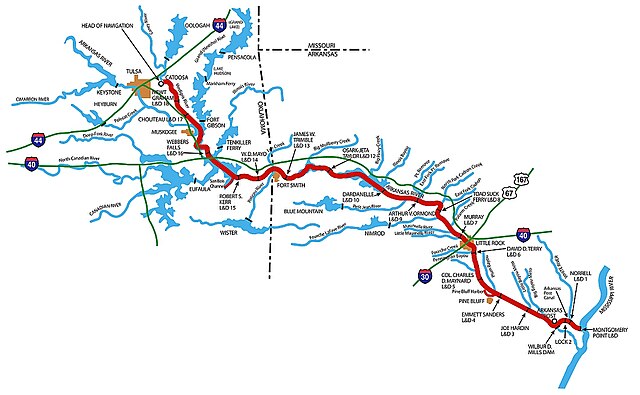
While the Arkansas River isn’t typically associated with nautical navigation like ocean or Great Lakes shipping, certain sections do require professional-grade charts for safe navigation. The lower Arkansas River, particularly the section maintained for commercial barge traffic, appears on official nautical charts published by the U.S. Army Corps of Engineers.
These professional Arkansas River maps include detailed information about channel depths, navigation markers, lock and dam locations, and restricted areas that casual recreational maps might not show. Commercial operators and serious recreational boaters use these charts to ensure safe passage through areas with heavy boat traffic or complex navigation challenges.
Navigation charts also include crucial information about bridge clearances, which becomes important for boaters using sailboats or other tall watercraft. This information appears as specific measurements on detailed Arkansas River maps and helps boaters plan routes that accommodate their vessel’s dimensions.
Weather and Water Level Monitoring
Current conditions information is essential for safe Arkansas River navigation, and modern Arkansas River maps integrate real-time data from various monitoring systems. The National Weather Service and USGS maintain extensive networks of monitoring stations along the Arkansas River that provide up-to-the-minute information about water levels, flow rates, and weather conditions.
Flood stage information appears on hazard-aware Arkansas River maps, showing areas prone to dangerous high water conditions. This information is crucial for boaters, campers, and anyone planning activities near the river during periods of heavy rainfall or rapid snowmelt.
Water temperature data also appears on specialized Arkansas River maps, particularly those designed for fishing or swimming activities. Temperature information helps recreational users plan activities and understand seasonal patterns that affect fish behavior and water-based recreation comfort levels.
Historical Significance of River Routes
Arkansas River maps tell the story of American development and westward expansion. The river served as a crucial transportation corridor for Native American tribes, early European explorers, fur traders, and pioneer settlers moving west during the 1800s.
The Santa Fe Trail, one of America’s most important historic trade routes, followed the Arkansas River for much of its course across Kansas. Historical Arkansas River maps show how traders and travelers used the river as both a navigation guide and a source of water during long journeys across the Great Plains.
Military history also appears on historical Arkansas River maps, with numerous frontier forts established along the river to protect travelers and settlers. Fort Larned, Fort Dodge, and Fort Smith all played crucial roles in frontier defense and show up prominently on maps depicting the Arkansas River’s role in American expansion.
The river’s importance to Native American cultures spans thousands of years, and ethnographic Arkansas River maps show the territories and travel routes of various tribes including the Osage, Quapaw, and Arapaho peoples. These maps help modern users understand the deep cultural significance of the Arkansas River beyond its current recreational and economic uses.
Environmental Conservation Areas
Modern Arkansas River maps highlight numerous protected areas and conservation zones established to preserve the river’s ecological health and natural beauty. These areas represent ongoing efforts to balance human use with environmental protection along this vital waterway.
The Arkansas Headwaters Recreation Area in Colorado appears prominently on conservation-focused Arkansas River maps. This area protects 152 miles of the Arkansas River and its tributaries while providing sustainable recreational access through carefully managed facilities and regulations.
Wildlife management areas along the Arkansas River in Kansas, Oklahoma, and Arkansas show up on specialized Arkansas River maps designed for hunters, birdwatchers, and wildlife enthusiasts. These areas provide critical habitat for migratory waterfowl, native fish species, and other wildlife that depend on healthy river ecosystems.
Wetland restoration projects appear on environmental Arkansas River maps as efforts to restore natural floodplain functions and improve water quality. These projects represent partnerships between government agencies, conservation organizations, and local communities working to ensure the Arkansas River remains healthy for future generations.
Safety Considerations When Using River Maps
No discussion of Arkansas River maps would be complete without addressing safety considerations that every river user should understand. The Arkansas River’s diverse conditions and remote sections require careful planning and appropriate safety preparations.
Water level fluctuations can dramatically change river conditions, making previously safe areas dangerous and altering navigation routes shown on static Arkansas River maps. Real-time monitoring and local knowledge become crucial supplements to traditional mapping resources.
Weather conditions along the Arkansas River can change rapidly, particularly in Colorado’s mountainous regions where afternoon thunderstorms can create flash flood conditions in tributary canyons. Safety-conscious Arkansas River maps include information about evacuation routes and emergency communication procedures for remote areas.
Hypothermia risk exists year-round in Colorado’s high-altitude sections of the Arkansas River, where water temperatures remain cold even during summer months. Safety-oriented Arkansas River maps include information about water temperatures and recommended protective equipment for different seasons and river sections.
Conclusion
Arkansas River maps serve as gateways to understanding one of America’s most diverse and historically significant waterways. Whether you’re planning a whitewater adventure in Colorado’s Rocky Mountains, a peaceful float trip through Kansas farmland, or exploring the cultural attractions of riverside cities, the right map makes all the difference in your experience.
Modern mapping technology has transformed how we interact with the Arkansas River, providing real-time information and interactive features that enhance both safety and enjoyment. From USGS topographic maps to smartphone apps with GPS navigation, today’s Arkansas River maps offer unprecedented detail and functionality.
The key to successful Arkansas River exploration lies in choosing the right mapping resources for your specific needs and understanding how to interpret the wealth of information these tools provide. Whether you’re a first-time visitor or a longtime river enthusiast, taking time to study Arkansas River maps before your adventure will enhance your appreciation of this remarkable waterway and help ensure a safe, memorable experience.
Remember that no map can replace good judgment, proper preparation, and respect for the river’s power and unpredictability. Use Arkansas River maps as valuable tools in your planning process, but always be prepared to adapt to changing conditions and prioritize safety above all other considerations.
Frequently Asked Questions
Q: What is the best type of Arkansas River map for whitewater rafting in Colorado?
A: For whitewater rafting, use specialized river maps that show rapid locations, difficulty ratings, and put-in/take-out points. The American Whitewater website and local outfitters provide detailed maps specifically designed for Colorado’s Arkansas River whitewater sections.
Q: Are there free Arkansas River maps available online?
A: Yes, the USGS provides free digital topographic maps covering the entire Arkansas River system. Google Earth also offers free satellite imagery and basic navigation tools. Many state tourism websites offer free recreational maps highlighting specific sections of the Arkansas River.
Q: How do I find current water levels when using Arkansas River maps?
A: The USGS Water Resources website provides real-time stream gauge data for monitoring stations throughout the Arkansas River system. Many mobile apps also integrate this information directly into their mapping displays for convenient access to current conditions.
Q: What should I look for in an Arkansas River fishing map?
A: Fishing maps should show access points, parking areas, special regulation zones, and species information. Look for maps that indicate productive fishing areas, seasonal patterns, and any restricted or private sections along the river.
Q: Can I use Arkansas River maps for winter activities?
A: While the river itself may be partially frozen in some sections during winter, Arkansas River maps are useful for planning ice fishing, cross-country skiing along river corridors, and winter wildlife viewing. Always check current ice conditions and safety information before venturing onto or near frozen sections of the river.